Celia Ann and Thomas Haynes of Jackson County, Texas
“Buy land; they’re not making it anymore.”
Mark Twain, 1835-1910
“But hold on to it after you buy it!”
Audrea Haynes Moyers, 2010
Mark Twain, 1835-1910
“But hold on to it after you buy it!”
Audrea Haynes Moyers, 2010
Note to cell phone users: Please click on the icon with three horizontal bars at the top of this page to bring up links to the major sections and sub-sections of this site.
The Haynes Place Within the Musquiz Grant
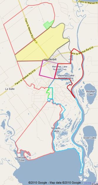
The Haynes Place shown yellow and green
In 1998, my wife Carolyn began doing research on her family tree. Her uncle, Milton Leon Broughton of Dublin, Texas, had previously completed her father’s family tree. After completing those of her other grandfather (Robert Hugh Henderson) and grandmother (Othia Othella Cain) and learning many of the ins and outs of genealogy research via the internet, she began working on my family trees. She completed my mother’s (Cynthia Elsie Alberta Branscum) in short order, thanks to her hard work and research previously done by distant relatives of mine and made available to Carolyn. Then she began work on my father’s tree (Louis Nicholas Haynes). This one was much more challenging and required trips to eastern Tennessee, western Kentucky, and southern Louisiana, as well as to Jackson, Calhoun and Victoria counties in Texas, until we could prove conclusively that the Thomas Haynes whose records we had found in Kentucky was the same Thomas Haynes who first came to Texas in 1844 and, as of 2017, has become the progenitor of eight generations of Texans.
There were at least two other men named "Thomas Haynes" in Texas about the time of our Thomas Haynes. One was Thomas S. Haynes, one of Stephen F. Austin's Old Three Hundred colonists, who settled in Brazos County. And there was a doctor named Thomas N. Haynes who lived in Victoria County and Jackson County during this time and also taught school in Morales de Lavaca. We found letters written by him in the Andrew Nelson Erskine collection at the Dolph Briscoe Center for American History in Austin. He and our Thomas Haynes shared the same era and locale, but he is not the Thomas Haynes of interest here. Be careful, because we think some historians may have the two confused.
This web site reports primarily about Thomas Haynes, his children and grandchildren, and one particular, large piece of land that he once owned, entirely within the Ramon Musquiz Grant in Jackson County. The “Haynes place” that Thomas and his wife, Celia Ann, established on the Lavaca River near Vanderbilt has now been passed down through six or seven generations. Most of it was sold off over the years as it was subdivided again and again with each passing generation, and what was originally about 4,000 acres of land in the Haynes family known as the "Haynes place” had been reduced to about 20 acres per heir when my father inherited his share in 1962, and the total was later reduced to about 125 acres, all of which was owned by descendants of my aunt, Ruth Haynes Hoffman. My cousin, Mary Meredith Hoffman Johnson and her husband Bill, own over 100 acres of that. The important thing, though, is that descendants of Thomas and Celia still live on the same land they lived on, and in practically the same location.
In assisting Carolyn with her research, being required to drive her around the country (quite willingly, of course), and serving as question-answerer and sounding board for her theories about the Haynes family, I became more interested in the story of Thomas Haynes and his descendants, and especially the land he had owned. I had never known that the Haynes place had ever been anything more than the 166½ acres that Grandma Haynes had owned when I was growing up. I was especially surprised to discover, on our first trip to the Jackson County courthouse to study the deed records, that Thomas Haynes had once owned not just 166½ acres of land, but 17,354 acres in the Ramon Musquiz Grant, and even more across other parts of Jackson County! Exactly what land did Thomas own, and what became of it all? I wanted to know. (Of course, it’s all still there, but someone else owns almost all of it.) So I began a land search while Carolyn continued the people search. As it turned out, the two searches were complementary since land deeds sometimes contain personal information, and knowing about the people sometimes helps explain what happened to their land.
As the weeks passed and we acquired more and more deeds and other documents on our trips to Jackson County, my appetite for knowing even more continued to grow, until I was determined to account for every one of the 24,354 acres in the Ramon Musquiz Grant. And not only did I want to know who bought and sold each piece of land, I also wanted to create a map showing each tract, with correct size and placement relative to all the others. On the parallel track, as Carolyn and I learned more and more about the land, we learned more and more about the Haynes people, and the same sort of appetite and goals developed there. What were the living conditions like back then? Why did they make the decisions they made? How were they influenced by current events? What kind of people were they? We have been able to answer some of those questions, but they remain largely unanswered. For me, only a face-to-face meeting with Celia Ann and Thomas Haynes would yield answers to all the questions I have.
But why spend all that time and money, and go to all that trouble, just to learn about these people and that land, knowing that nothing can change things? (Not that anything needs changing.) Well, first of all, it's a very challenging endeavor that helps keep our brains stimulated as we grow older. It is no small task to take a deed written in 1850 that describes property boundaries in terms of local landmarks, with no measurements or bearings, and turn that into an area on a map, properly sized and placed. Multiply that effort by thirty and you will get an idea of the immensity of the project. Second, we learned a lot about what we represent, in terms of the people who got us to where we are. Hopefully, our children and grandchildren, cousins, nieces and nephews will have an increased awareness and appreciation of who they are. And finally, things can be changed, because I have been changed by what I have learned.
Although many things we do in life are recorded using only the names of the men involved (and that trait will show up here), after working on this project for a while it soon became obvious to us that the true “main character” of the story was not Thomas Haynes, but his wife, Celia Ann Webb Haynes, my great-great-grandmother. Celia outlived Thomas by about thirty years, yet managed to hold her family and the Haynes place together through what must have been cataclysmic years during and after the Civil War and Reconstruction. All four of her sons and at least one of her two daughters preceded her in death, causing untold grief while also depriving her of much of the help she needed in managing a large ranch during very trying times.
Herbert R. Haynes, October, 2010 (revised April, 2017)
How To Use This Web Site More Productively
If you're just browsing around to see what's here, just follow the links in the navigation bar and then the links within the pages you visit. That will work just fine. Click your browser's "Go back one page" icon with your mouse to go back to where you came from, or click one of the items in the navigation bar shown above, which appears at the top of every page. If you wind up on a Google map, which will be shown in a new browser tab or window, close that tab or window when you are finished with the map. If you want to keep the map handy, leave its tab or window open and click instead on the original tab or window to switch back to it. In other words, just use the features of your browser.
Which of those links in the navigation bar should you follow first, and in what order should you follow them? You were started at Home, of course. After that, it kind of depends upon what you're most interested in. The following is a brief description of what is available through each of the navigation bar links.
The Timeline link takes you to a list of events in chronological order during the history of the Musquiz Grant, the acquisition of the land by Thomas Haynes and Edward M. Glenn, the sale of some of the land, the lives of the first three generations of people at the Haynes place, their eventual division of the land, and a few important national and international events during their lifetimes. For most of these, there is a link to a discussion, and from many discussions there is also a link to the related deed. Consequently, the Timeline link takes you to the history of the Haynes place.
The People link takes you to the various forms of family trees for the Haynes people. But there are no discussions there; just basic information about the people, their birth dates, death dates, marriage dates children, etc. The People material also includes a census summary for the Haynes place for every ten years from 1850 to 1930.
The Places material is primarily a collection of links to various maps of the Musquiz Grant and the Haynes place, including a link to each of the numerous maps I created, even though that map may not have been referenced elsewhere. It also contains material describing some of what is available at the Texas General Land Office web site and how to use it, as well as specific identifying numbers of several maps of interest in Jackson and Victoria counties.
The Stories item is a pull-down list of links to discussions we have written about particular topics, such as how we proved that our Thomas Haynes of Texana was the same Thomas Haynes who grew up in western Kentucky, the son of "Squire Kit" Haynes, and who came to Texas via Louisiana.
The Documents link takes you to a page of links to deeds and other documents related to the Musquiz Grant and the Haynes place, but arranged essentially in chronological order. So this section is a sort of history via deeds and documents, without any discussion other than notes I have added to some deeds. However, if you follow the link from a deed to a Google map, the notes attached to the map will contain some discussion.
The Process link takes you to a discussion of the process I followed in figuring out all of the land deals and drawing all the maps. It includes sections on using Google Maps in land research, locating a piece of property on a Google map, describing property using metes and bounds, and the Mexican system of measurement used in early Texas. There's also a link to an historic early Texas map at the Texas General Land Office web site.
If you are going to check out a substantial part of what's here and pay attention to the details, you may want to make sure that you are doing it efficiently, because there is a great deal of redundancy built into this site. By redundancy, I mean that this site is not a nice, well-shaped tree with only one path to every page. Instead, there are multiple paths to many pages, so it's like a tree whose limbs may have grown together out away from the trunk. For example, consider a single deed. That deed is directly accessible from the Documents item in the top-level navigation bar. That deed is also indirectly accessible from the Timeline item, because the timeline contains a link to a discussion about each land deal, and each of those discussions probably contains a link to one or more deeds. Finally, that deed may be accessible from other discussions, documents, or Stories. Consequently, you may wind up seeing a link to the same deed more than once. If you're not interested in reading it again, don't follow the link or just click the "Go back" button if you wind up on a page you've already seen. (You will notice that the links are color-coded -- a blue link has not been followed yet whereas a green link has been followed at least once. A link will turn red when your mouse is hovering over it.)
A similar problem may occur with the maps. You may get tired of having to repeatedly follow a link to a Google Map, only to see the same map drawn over and over again. Or you may want to see the map, but haven't been provided a convenient link to it where you need it. One way of speeding things up is to show that map in a separate browser tab or window, or to run a second copy of your browser in a separate window, with that window containing the map. Then when you need to see the map, you can just click on the other browser tab or window. Or, if your computer's screen is large enough, you can display two windows at once, one for the map and the other for your normal browsing. If you wish to use this approach, the map most frequently used is shown on the upper part of this Home page. If that is not the map you want to see, just pick out the one you want and follow the same approach.