Land Deal: Two labors that had belonged to A. M. Clare and Samuel P. Middleton
The first land Thomas Haynes purchased in Jackson County, on Aug. 2, 1845, was two adjoining labors (177 acres each, or 354 acres total) on the east side of the Lavaca River. He paid $1 per acre, or $354 total, for the land. This land was bought from Hamlet Ferguson of (Port) Lavaca, Texas, who had just obtained it from Sam P. Middleton and A. M. Clare, each of whom was the original grant recipient. The purchase price seems excessive when compared to other land sales of the time, but riverfront land was the most desirable, and it is unknown whether either piece of land contained any improvements. The deed mentions that the land was near the Atascosita Road, which was the major road from Victoria to Columbus and which crossed the Lavaca River here.
The first land Thomas Haynes purchased in Jackson County, on Aug. 2, 1845, was two adjoining labors (177 acres each, or 354 acres total) on the east side of the Lavaca River. He paid $1 per acre, or $354 total, for the land. This land was bought from Hamlet Ferguson of (Port) Lavaca, Texas, who had just obtained it from Sam P. Middleton and A. M. Clare, each of whom was the original grant recipient. The purchase price seems excessive when compared to other land sales of the time, but riverfront land was the most desirable, and it is unknown whether either piece of land contained any improvements. The deed mentions that the land was near the Atascosita Road, which was the major road from Victoria to Columbus and which crossed the Lavaca River here.
A portion of GLO historic map 3708 of Jackson County
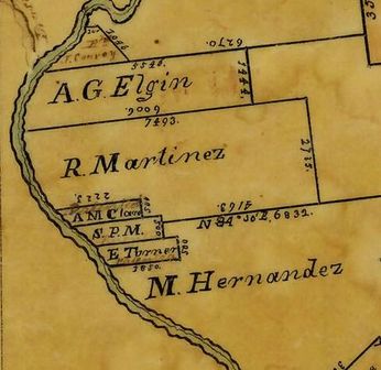
With a little work, these two tracts can be located on GLO maps 3707-3708 of Jackson County. (Only map 3708 is shown here.) The areas are small compared to the much larger “league and a labor” tracts, so there wasn’t much room on the original maps to show who owned them, but “A. M. Clare” is there, along with “S.P.M.”, along with a similar-sized tract granted to E. Turner. GLO Map 3707 shows a portion of the Atascosita Road where it crosses the Lavaca River through a labor of land granted to Joseph F. McLaurince. Moving northeast across the map leads to an indication of where the road crossed the Navidad River. Map 3707 also shows the dates that each of the grants was made. Map 3708 is clearer, and shows mostly boundary bearings and lengths for the various grants.
A portion of GLO historic map 5012 of Lavaca County
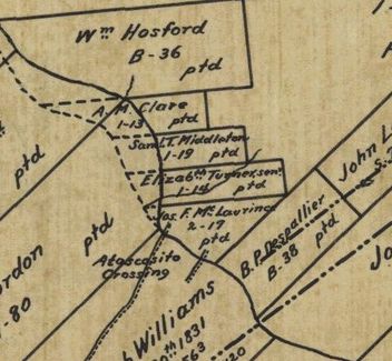
This land was well up the Lavaca River, below a spot called Rocky Ford or Rocky Crossing. In fact, the land is so far north that it eventually became part of Lavaca County, rather than Jackson County. Consequently, this land may be found on some Jackson County maps and on some Lavaca County Maps. GLO Map 5012 of Lavaca County, drawn in 1896 and shown here, is especially clear. This small portion of the map is from the very bottom (south) near the county line, which is shown cutting across the lower-right-hand corner of the map just below the land of "B. P. Despallier." The map also shows the Atascosita Road crossing of the Lavaca River, and suggests that the course of the river changed substantially in this area, causing land loss to the owners of these two tracts. Being on the Texas coastal plain, Jackson County is "flatter than a pancake" and the Lavaca and Navidad rivers have tended to wander all over the place over the years.
No sale transaction(s) could be found for these two tracts in the Jackson County deed books, so I was beginning to wonder whether Thomas simply forgot to sell them, or perhaps did not have the deeds recorded. But after examining the various GLO maps, I discovered that these tracts did not even appear on some later Jackson County maps. Instead, portions of Jackson County, including this land, had been shifted to the north into Lavaca County. So we figured that if the land had been sold, the deeds would be in the Lavaca County deed books. This necessitated a visit to still another county seat; this time to Hallettsville. Sure enough, in the special book of deeds for Lavaca County land for which the deeds had been recorded in some other county first, we found the deed of sale in Volume B, page 304. Thomas Haynes sold both 177 acre tracts to Josiah Evans for $177 on April 4, 1853. So after holding title to this land for eight years, receiving no interest on the $354 he had invested, and paying perhaps $1.06 per year in taxes, Haynes sold it for only one-half of what he had paid for it. For his first land purchase/sell deal in Texas, Haynes got off to a very poor start; fortunately, much more had happened in the interim, as described elsewhere.
This land is a good distance from (Port) Lavaca, about 40 miles as the crow flies, where Thomas was staying or living at the time, so it is reasonable to wonder whether he visited this land before he bought it, or whether he bought it sight unseen. But because of his eventual purchase of much more land in Jackson County, it is easy to imagine that he explored the area on horseback, perhaps accompanied by a paid guide, or by Hamlet Ferguson of Lavaca, from whom he bought the land. During that trip in 1844 or 1845, he would have seen the beauty and potential of Jackson County, and decided to make his home there.
To describe the location of this land in more modern terms, consider Texas Highway 111 from Edna northwest toward Highway 77 and Yoakum. About 7 miles northwest of Morales, Highway 111 crosses the Lavaca River, and this land is just to the left (southwest) of the highway just before the road crosses the river. This Google map shows the approximate location of the two labors of land.
Source: Jackson County deed records, volume B, page 446, and Texas General Land Office maps 3707 and 3708 (Jackson County) and Lavaca County deed records, volume B, page 304, and GLO maps 283, 3802-3804, and 5012 (Lavaca County).