The Original Musquiz Grant Survey

At the Jackson County Clerk's office in Edna, we were able to get a copy of some of Musquiz Grant documents that had been translated into English by the Texas General Land Office in 1913, as well as an 11 x 17 inch copy of the original survey map drawn by the Mexican surveyor, Jose M. J. Carvajal. I am not sure how the copy of the map was made in 1913, but assume that it was traced over the original. The map was too large to scan in a single pass on our scanner, so I scanned it in two passes, printed each one slightly smaller, cut and pasted them together, and then scanned that to get the final map that appears here on the left. It's pretty close to the original, except that it is smaller, which makes the writing difficult to read. So just in case you want to know what it says, here goes: starting at the top left and going counter-clockwise around the map's perimeter, we have "North Magnetic", "S.W. 4702 vs.", "S 30° E 8946 vs.", "Venadito Creek", "S 28° 10' W 7450 vs.", "Mouth of Garcitas", "Matagorda Bay", and "Lavaca River". Inside the lower part of the map reads "High Land" and "Low Land Marshy". On the left is "Scale 2000 vs. per inch" and "Original map of five and one-half leagues of land surveyed for D. Ramon Musquiz, Jose M. J. Carvajal, Sur." and "rubric" encircled. The abbreviation "vs." stands for "varas." Of course, only the scale of the original map was 2000 varas per inch; I have no idea what the scale on this one is.
If you will notice, the surveyor showed a creek flowing into the Lavaca River in the upper portion of the map. That's the northern boundary of the Haynes place. The major bend in the river at that point is still there today because there's a very high bank on the south side that the river has not be able to erode away, but the map does indicate that some significant changes in the course of the river have occurred below that point (when compared to a modern map). The bay that the surveyor labeled as "Matagorda Bay" is known as "Lavaca Bay" today, but Lavaca Bay is just a smaller bay within Matagorda Bay. Notice that the map does not show any of the Navidad River, which joins the Lavaca about a quarter of the way down from the top. By way of comparison, follow this link to see the Google Maps outline of the Musquiz Grant land as it exists today.
One question I had early on was "Where is the northern "corner" of the Musquiz Grant land on the Google map?" The original survey just shows that the upper line meets the river somewhere along that big curve in the river, but exactly where along that curve is the intersection? At first, I thought the upper line coincided with what is now County Road 311, but measuring 4,702 varas (4,354 yards) along that line to the SW as the survey indicates did not take me to any place "interesting," such as a road leading S 30° E to match the "back line" or SW side of the Musquiz tract. But I finally wised up and moved my upper line on up the river a little and found the right spot (which corresponds to a large gully that flows into the river) and everything fell in place from there.
The Musquiz Grant and Its Neighbors
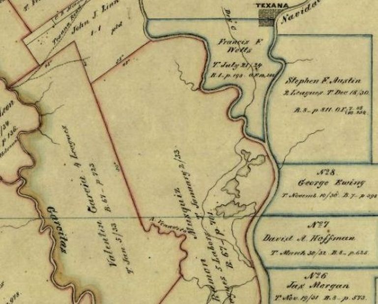
Incidentally, all of the land to the NW and SW of the Musquiz tract had already been surveyed for other Mexican land grants before the Musquiz surveyor came along, so all the Musquiz surveyor had to do there was to find the other guys' stakes and verify the measurements. As shown above on a screen shot of a portion of the Texas General Land Office (GLO) historic map 4115 from 1858, on the NW end was the John J. Linn Grant, and on the SW side was the Valentin Garcia Four Leagues Grant. Back then, the land west of the Lavaca River was part of Victoria County. On the east side of the river was Jackson County and the western-most grants given by Stephen F. Austin. Just barely showing here at the top of the Francis F. Wells Grant between the Lavaca and Navidad rivers is the town of Texana.
(Be sure to follow the link above to (eventually) reach GLO map 4115. It's very interesting. The link will not take you directly to the map. Instead, it will take you to The Map Collection page. From there, click on Search Historic Maps, which will take you to the Archive Maps page. Toward the bottom of that page in the Map/Document # field, enter the map number (4115) and then click Search. When the map appears, you will need to click on the magnifying glass and then again on the "+" several times to get the degree of magnification that you need. Then you can "drag" the map around with your mouse to check things out. The Musquiz Grant land is near the center of the map, on the right hand side.)
(Be sure to follow the link above to (eventually) reach GLO map 4115. It's very interesting. The link will not take you directly to the map. Instead, it will take you to The Map Collection page. From there, click on Search Historic Maps, which will take you to the Archive Maps page. Toward the bottom of that page in the Map/Document # field, enter the map number (4115) and then click Search. When the map appears, you will need to click on the magnifying glass and then again on the "+" several times to get the degree of magnification that you need. Then you can "drag" the map around with your mouse to check things out. The Musquiz Grant land is near the center of the map, on the right hand side.)