Celia A. Haynes Gives 300 Acres to Her Grandson, Thomas S. Haynes (Celia's 300)
We know very little about Thomas and Celia’s two youngest sons, Arthur and Robert, but from the deed records, we know that neither was given any Haynes place land. We discovered that both Arthur and Robert were married, and we had a note that Celia had been involved in a deed with a Thomas S. Haynes. We suspected, of course, that Thomas S. must have been one of her grandsons, but didn’t know whether he was Arthur’s son or Robert’s son. In yet another trip to Edna, we finally obtained a copy of that deed, hoping that it would mention Celia’s connection to Thomas S. It did; and we found that Thomas S. was Celia’s grandson, the son of her deceased son, Arthur, who died in 1888.
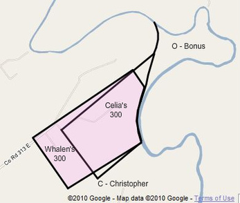
On May 24, 1889, as recorded in Book O, page 544, Celia Haynes gave 300 acres of her 960 acres of remaining Haynes place land to her grandson, Thomas S. Haynes, who was about 19 years old at the time. The boundaries of the land were described as follows:
On May 24, 1889, as recorded in Book O, page 544, Celia Haynes gave 300 acres of her 960 acres of remaining Haynes place land to her grandson, Thomas S. Haynes, who was about 19 years old at the time. The boundaries of the land were described as follows:
"Beginning at a point three hundred yards due north of the house in which I now reside;
"Thence running to the bank of the Lavaca River on a line parallel to the upper line of the aforesaid 960 acre tract;
"Thence down the Lavaca River with its meanders to such a point that a line run thence parallel with the first line herein toward the back line of said 960 acre tract shall be 900 yards in perpendicular distance from said first mentioned line;
"Thence continuing said line from the last mentioned point on the river toward said back line to such a point that a line run thence at right angles with said last mentioned line 900 yards to corner;
"And thence parallel with third line herein to place of beginning shall contain 300 acres as aforesaid and shall also include in said boundaries all the houses and other improvements on the place where I now reside."
This land was supposed to coincide with area (Celia's 300) on the map shown here (and area (3) on many other maps). Because of changes in the course of the river during the past 120 years, that area is now more on the order of 475 acres than 300 acres, which led to my designation of the Bonus area (O). None of the early maps of Jackson County shows the two loops in the river that are present today, so the river’s course has changed considerably. But most of the problem may be associated with a surveying error somewhere along the way, because some boundary lines were run at S 45 W while others were run at S 50 W. This caused Celia's 300 acre area to overlap the land that had been given to Christopher. In the long run, this required a new survey for Christopher's land in order to provide him with the full 640 acres, and an eventual resurvey of the 300 acre tract by Mary Julia and Michael Whalen to get it in line with everything else. That Whalen survey, done in 1894 or earlier, essentially acknowledged the existence of the bonus area.
As stated in Celia's deed to Thomas S., this area was supposed to be 900 yards wide, but in the resurvey, this same area was 1,000 varas (926 yards) wide. This area was supposed to extend all the way to the river on the east, but in the later Whalen resurvey, this same area was split into a 300 acre tract and a bonus area.
This deed reveals that Celia was not living in what has always been considered to be the home site of the Haynes place (at least for the past 100 years or so), which is up at the far northeast corner of area (R), on the river and near the gully at the top of the Haynes place. Rather, she was living over a mile away in a home that eventually became the home of the Whalens and then the Fenners. Thomas S., and perhaps Amos and his third wife, Jennie, may have been living there with Celia, as they had been in 1880 (excluding Jennie). We can only assume that Celia continued to live in the house, even though she had given it to Thomas S.
At this stage in the history of the Haynes place, Amos owned the upper 1,400 acres; Celia owned 660 acres out in the prairie below that; Thomas S. owned 300 acres on the river east of Celia’s; and Christopher owned the lower 640 acres. Either Celia or Amos owned 750 acres or so in area (P) out in the prairie to the southwest.