Musquiz Grant Land Broken Down into Areas of Interest
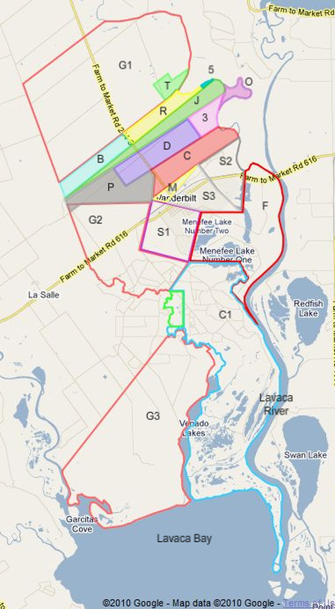
Several of the maps that include the entire Musquiz Grant area show each of the 20 smaller areas that I have decided to divide the Musquiz Grant land into for discussion purposes. Areas within the original Haynes place are completely shaded or colored. For ease of reference, I have assigned a very brief label (defined below) to each area, and these labels have been added to some maps.
All of these areas were once owned by either Edward M. Glenn or Thomas Haynes. We have not studied the history of all of this land past the third generation (the “Thomas Haynes grandchild stage”), except for the one particular area (R) that has “always” been known, though perhaps reduced in size, as “the Haynes place” and was the home of my father when he was a boy. Likewise, we have not attempted to determine what happened to the land that Edward M. Glenn owned (outlined in orange), although anything of interest that we discovered is reported here.
The collection of all 20 areas represents the entire 24,354 acres area of the Musquiz Grant. Each of the individual areas represents a piece of land that was involved in a land transaction handled by either Edward M. Glenn or Thomas Haynes or one of his early descendants and described in a deed that is available at the Jackson County courthouse and included here via both the "Documents" link and the "Timeline" link in the navigation bar at the top of every page.
The twenty areas are listed below. You may follow this link to the actual Google Map.
Label Acres Description
G1 5,000 Glenn’s remaining land on the north end of the Musquiz Grant
G2 2,500 Deeded to Glenn by Haynes in their division of the Musquiz Grant land
G3 5,000 Deeded to Glenn by Haynes in their division of the Musquiz Grant land
T 170 “100 acres of timber and bottom land” purchased from Glenn by Haynes
5 5 Inherited from Amos Haynes by Blanche C. Haynes Owens
R 367 Inherited from Amos Haynes by Richard Daniel Haynes (my grandfather)
B 402 Inherited from Amos Haynes by Blanche C. Haynes Owens
J 625 Inherited from Amos Haynes by Mary Julia Haynes Whalen
D 660 Originally given to Daniel but later sold to Michael C. Whalen
3 300 Involved in all sorts of transactions, and having multiple boundary definitions
O 125 A "bonus" area caused by river course changes that sometimes was involved with (3) above
C 640 Given to Christopher Haynes by his mother, Celia Ann Haynes
P 750 Pasture land on the southwestern prairie that seems to have been forgotten
S1 1,000 Sold to James J. Stone by Thomas Haynes
S2 612 Sold to James S. Stanton by Thomas Haynes
S3 500 Sold to James S. Stanton by Thomas Haynes
M 138 Traded to George Menefee, Jr. by Celia Haynes in exchange for share of fences
F 2,400 “Forks tract” sold to the Schneider estate by the Thomas Haynes estate
BH 200 Sold to Thomas G. Bankhead by Thomas Haynes
C1 6,000 Sold to Daniel P. Coleman by Thomas Haynes
The numerically-inclined reader will discover that the total acreage listed above is over 27,000, whereas the Musquiz Grant was supposed to contain only 24,354 acres. The major source of the difference is that the area stated by surveyor Jose M. J. Carabjal does not include what he called "the permanent lakes and marshes." In the list above, although most of the smaller numbers are precise, the larger numbers are mostly only estimates. It is highly unlikely that the surveyor could accurately measure this entire tract within a reasonable amount of time and state that it was exactly 5½ leagues, especially considering the tidal areas along Lavaca Bay and the Lavaca River floodplain, and Thomas Haynes and Edward M. Glenn made large mistakes in estimating the areas of the larger tracts.
These are not the only areas involved in the history of the Haynes place, but I chose not to include some other areas that would overlay these. In particular, areas D, 3, and O were all involved in numerous transactions, sometimes with 3 and O combined, sometimes with 3 by itself, sometimes with 3 by itself but with different boundaries, etc. (I think I have finally figured it all out, but whether I can explain it to you remains to be seen.)
Not only does an area on the map represent a piece of land, but its shape and placement also correspond fairly closely to the real piece of land, just like a normal map. Notice that the map does not represent current ownership of land, since most of these areas have been subdivided many times during the past 160 years. The objective here was to find out where Thomas Haynes’s land was and what became of it after he and his wife Celia passed away.