The Thomas Haynes Estate Sells 2,400 Acres to the Schneider Heirs (Area F)
The Forks Tract Sold to the Schneider Estate
On December 8, 1866, Christopher Haynes, as executor of the Thomas Haynes estate, sold “800-900 acres” (area F, known as "the forks tract") to the administrator (Henry Starr) of the estate of a man named Schneider, who had three minor children. It was an interesting transaction, because it turned out that Schneider’s estate owed $2,124.70 to Thomas’s estate for legal work. (Thomas himself had been administrator of the Schneider estate before Thomas died, as we found in a land transaction in Victoria County.) Mr. Starr, the new administrator, agreed to pay that debt if Christopher would throw in the 800-900 acres of land in the forks tract for free. Times were tough and the land under consideration was considered to be marginal, so Christopher agreed and the “sale” was made, as recorded in Book G, page 309.
The land being sold was described as follows (items in parentheses added):
"… lying at the mouth of said river or thereabouts and known as “the forks tract” (actually, not the mouth, but upstream where the Lavaca and Navidad meet), and bounded as follows:
"Beginning for the lower corner of this tract at the upper corner on the banks of the Lavaca River and on its western side of a tract of land sold by Thomas Haynes to Daniel R. Coleman on the 21st day of February A.D. 1851;
"Thence with said Coleman’s line to the head of the bayou (Menefee Bayou) to said Coleman’s corner in a lake or pond, which it enters;
"Thence to the corner of land sold to James M. Stanton and back corner (Stanton had bought Stone's 1,000 acres in the square tract);
"Thence along Stanton’s side lines on the lower side thereof for the upper line of this tract, to Stanton’s lower corner on the bank of said river;
"Thence down the river with its meanders to the place of beginning, so as to include all the land between the lands of James M. Stanton, James J. Stone, and Daniel R. Coleman as aforesaid, being 800 or 900 acres more or less.
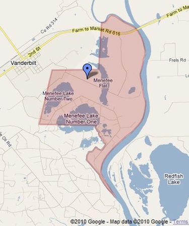
If this tract is viewed in “Map” mode as shown above, it is obvious that it contains a large area of marsh land and lakes. But what Christopher was selling as “800-900 acres” actually was over 2,400 acres (including the lakes and marshland), according to Google Maps. Obviously, he made significant allowances for the areas covered in lakes and marshes. It could be possible that the State of Texas was considered to be the owner of the lakes and other tidal areas as “submerged lands.” (Although the conventional wisdom must have been that the marsh area was of minimal value, the eventual discovery of oil and gas changed all of that.)
With Christopher selling this land as being only 800-900 acres, while Google Maps shows over 2,400 acres, we are naturally led to wonder where I messed up. Those guys weren’t dummies back then! I have re-examined the deed from Thomas Haynes to Daniel P. Coleman, who purchased the large expanse (C1) along the lower Lavaca River, to ensure that I had interpreted it properly, because the upper line of that property is the bottom line of this one. Moving the Coleman line up some would reduce the amount of land in the Schneider tract, but I could not find anything to justify that. The Coleman deed is quite clear, and says that his upper property line was to be from the river, up Menefee Bayou to Menefee Lake Number One, and then straight over to the starting point at the lower corner of Stone’s 1,000 acre square tract (S1). (Stone had sold his land to Stanton before this Schneider deal). Here’s part of the Coleman deed:
"Beginning at the southerly corner of a tract sold by said Haynes to James J. Stone, being in elm or elms on the side of the bluff, thence a straight line to the lower corner of the tract conveyed by said Haynes to Edward M. Glenn on the Venado Creek, the east side being 400 varas (370 yards) below a drain or trench pointing in from the northeast side,
"Thence down the said creek with its meanders to its mouth;
"Thence along the bay shore (Lavaca Bay) to the mouth of the Lavaca River;
"Thence up the said river with its meanders to the mouth of the first bayou above Dimmitt’s point (Menefee Bayou);
"Thence up the said bayou to its head being the first lake or pond into which it enters (Menefee Lake No. One), thence a straight line to the beginning."
Similarly, the Schneider land also was to follow Menefee Bayou, but on the river side. I simply could not find a flaw in any of my thinking that would invalidate my conclusions. Then, while rewriting this section to explain the dilemma, I decided to re-read the original description of the Musquiz Grant by Mexican surveyor Jose M. J. Carbajal. He stated that the Musquiz tract containied 5½ leagues, "excluding the permanent lakes and marshes enclosed therein." So the total area of the Musquiz Grant was larger that 5½ leagues, and Christopher was correct in counting only the non-marshy areas in the land he was selling to the Schneiders. (Of course, this creates still another dilemma, because Thomas Haynes had sold Daniel R. Coleman what was supposed to be 6,000-8,000 acres below this in area (C1), but that area measures only 6,000 acres under Google Maps, so Coleman received no credit at all for marshy areas, of which there were many. But Coleman paid only 13⅓ cents per acre, whereas others paid $0.50 or more, so perhaps he and Thomas adjusted the price downward to reflect the presence of the marshy areas.)
This area is a part of what ultimately became known as the “Menefee Flats” and the “Menefee Lakes,” suggesting that the Schneider’s administrator went on to sell the land to George Menefee or George Jr. This suggestion is indeed true, as we found in a later deed; they sold it for $1,000. This entire lake and marsh area is tidal; that is, ebbs and flows with the tide in Lavaca Bay via the river and Menefee Bayou. The two lakes are connected by another bayou. My older brother, Martis, and I spent countless hours in this area, getting there either by walking through the woods from Vanderbilt or riding a bicycle along the washboard shell road from Vanderbilt to the “Humble Camp,” then down the steep hill and out into the flats. We seined for shrimp and redfish in Menefee Lake Number One, which to us was “the second lake,” and came home with good catches a few times, but I still remember that it was always a long way home after an exhausting day "in the flats."
The land being sold was described as follows (items in parentheses added):
"… lying at the mouth of said river or thereabouts and known as “the forks tract” (actually, not the mouth, but upstream where the Lavaca and Navidad meet), and bounded as follows:
"Beginning for the lower corner of this tract at the upper corner on the banks of the Lavaca River and on its western side of a tract of land sold by Thomas Haynes to Daniel R. Coleman on the 21st day of February A.D. 1851;
"Thence with said Coleman’s line to the head of the bayou (Menefee Bayou) to said Coleman’s corner in a lake or pond, which it enters;
"Thence to the corner of land sold to James M. Stanton and back corner (Stanton had bought Stone's 1,000 acres in the square tract);
"Thence along Stanton’s side lines on the lower side thereof for the upper line of this tract, to Stanton’s lower corner on the bank of said river;
"Thence down the river with its meanders to the place of beginning, so as to include all the land between the lands of James M. Stanton, James J. Stone, and Daniel R. Coleman as aforesaid, being 800 or 900 acres more or less.
If this tract is viewed in “Map” mode as shown above, it is obvious that it contains a large area of marsh land and lakes. But what Christopher was selling as “800-900 acres” actually was over 2,400 acres (including the lakes and marshland), according to Google Maps. Obviously, he made significant allowances for the areas covered in lakes and marshes. It could be possible that the State of Texas was considered to be the owner of the lakes and other tidal areas as “submerged lands.” (Although the conventional wisdom must have been that the marsh area was of minimal value, the eventual discovery of oil and gas changed all of that.)
With Christopher selling this land as being only 800-900 acres, while Google Maps shows over 2,400 acres, we are naturally led to wonder where I messed up. Those guys weren’t dummies back then! I have re-examined the deed from Thomas Haynes to Daniel P. Coleman, who purchased the large expanse (C1) along the lower Lavaca River, to ensure that I had interpreted it properly, because the upper line of that property is the bottom line of this one. Moving the Coleman line up some would reduce the amount of land in the Schneider tract, but I could not find anything to justify that. The Coleman deed is quite clear, and says that his upper property line was to be from the river, up Menefee Bayou to Menefee Lake Number One, and then straight over to the starting point at the lower corner of Stone’s 1,000 acre square tract (S1). (Stone had sold his land to Stanton before this Schneider deal). Here’s part of the Coleman deed:
"Beginning at the southerly corner of a tract sold by said Haynes to James J. Stone, being in elm or elms on the side of the bluff, thence a straight line to the lower corner of the tract conveyed by said Haynes to Edward M. Glenn on the Venado Creek, the east side being 400 varas (370 yards) below a drain or trench pointing in from the northeast side,
"Thence down the said creek with its meanders to its mouth;
"Thence along the bay shore (Lavaca Bay) to the mouth of the Lavaca River;
"Thence up the said river with its meanders to the mouth of the first bayou above Dimmitt’s point (Menefee Bayou);
"Thence up the said bayou to its head being the first lake or pond into which it enters (Menefee Lake No. One), thence a straight line to the beginning."
Similarly, the Schneider land also was to follow Menefee Bayou, but on the river side. I simply could not find a flaw in any of my thinking that would invalidate my conclusions. Then, while rewriting this section to explain the dilemma, I decided to re-read the original description of the Musquiz Grant by Mexican surveyor Jose M. J. Carbajal. He stated that the Musquiz tract containied 5½ leagues, "excluding the permanent lakes and marshes enclosed therein." So the total area of the Musquiz Grant was larger that 5½ leagues, and Christopher was correct in counting only the non-marshy areas in the land he was selling to the Schneiders. (Of course, this creates still another dilemma, because Thomas Haynes had sold Daniel R. Coleman what was supposed to be 6,000-8,000 acres below this in area (C1), but that area measures only 6,000 acres under Google Maps, so Coleman received no credit at all for marshy areas, of which there were many. But Coleman paid only 13⅓ cents per acre, whereas others paid $0.50 or more, so perhaps he and Thomas adjusted the price downward to reflect the presence of the marshy areas.)
This area is a part of what ultimately became known as the “Menefee Flats” and the “Menefee Lakes,” suggesting that the Schneider’s administrator went on to sell the land to George Menefee or George Jr. This suggestion is indeed true, as we found in a later deed; they sold it for $1,000. This entire lake and marsh area is tidal; that is, ebbs and flows with the tide in Lavaca Bay via the river and Menefee Bayou. The two lakes are connected by another bayou. My older brother, Martis, and I spent countless hours in this area, getting there either by walking through the woods from Vanderbilt or riding a bicycle along the washboard shell road from Vanderbilt to the “Humble Camp,” then down the steep hill and out into the flats. We seined for shrimp and redfish in Menefee Lake Number One, which to us was “the second lake,” and came home with good catches a few times, but I still remember that it was always a long way home after an exhausting day "in the flats."