Thomas Haynes Sells 500 Acres to James M. Stanton (Area S3 to the West of Stanton's Area S2)
About two and a half years later, on February 15, 1854, and for only $150, Thomas Haynes sold James M. Stanton another piece of land (S3), 500 acres this time, located on the southwest side of Stanton’s existing 612 acre tract (S2) and extending over to the northern side of James Stone’s 1,000 acre tract (S1). (Though it looks almost like a triangle when viewing the map at a large scale, it is actually a five-sided area, which becomes apparent when the image is zoomed-in for a closer look.) Some of this is not high-quality land, since it includes marshes east of Vanderbilt, but the higher land includes the remainder of present-day Vanderbilt, plus good farmland around it.
The deed (Book E, page 347) contained no lengths or bearings for any of the five boundary lines, but simply stated that the boundary was as follows:
"Beginning at the southern corner of a tract of 612 acres heretofore conveyed by said Haynes to said Stanton;
"Thence to the eastern corner of a 1,000 acre tract conveyed by said Haynes to James Stone;
"Thence westward with Stone’s line so far that a line run to the westerly corner of said six hundred and twelve acres tract to the beginning, will contain five hundred (500) acres.
Stanton's Additional 500 Acres (S3)
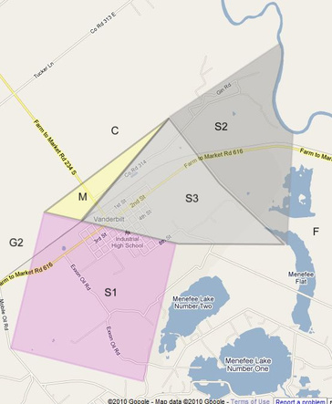
This land cannot be located on a map until the two previously-sold tracts (S1 and S2) have been located. A formal survey would eventually be required, since it would be impossible to determine where to place the upper or NW line in order to give 500 acres without knowing the lengths and bearings of the other boundary lines. In my case, all I had to do to draw this property on the Google map was to draw S1 and S2 and then use the “Area and Distance Calculator” to help locate the upper line.