Thomas Haynes Gives 1,280 of Haynes Place Land to Daniel Haynes (Areas D and C)
Celia Ann Haynes Buys it Back Three Years Later
On August 7, 1857, Thomas Haynes gave 1,280 acres of Haynes place land to his oldest son, Daniel, as described in Book E, page 626 of the Jackson County deed records. Daniel was born in Kentucky to Thomas’s first wife, Emma, and at this time would have been about 29 years old. Without claiming that the exact sequence of events described here is true, we do know that Daniel got married and decided to leave home to seek his fortune. During his career, he was a successful soldier, farmer, cotton gin builder and operator, and highly successful mattress inventor and manufacturer. The techniques he developed and patented for manufacturing comfortable (non-lumpy), cotton-filled mattresses when he lived in Sealy, Texas, eventually became the basis for the formation of the Sealy Mattress Company, which exists even today and is the largest bedding manufacturer in the world.
Perhaps as a means of providing Daniel with a solid financial start, his stepmother, Celia, bought the land back from him for $3,000 on July 6, 1860, as described in Book G, page 24. This gift and buyback may have been intended all along. Not only did this give Daniel a good start, but it also moved 1,280 acres of land out of Thomas’s name (if Thomas had bought back the land) and into Celia’s. This reduced the size (value) of Thomas’s estate, and thus reduced the amount of estate taxes that would be owed when he died. But if Thomas had expected Daniel to keep the land and was going to treat all of his four sons equally, he was not going to have enough land. (For some reason, this deed was not submitted for recording with Jackson County until 1869, perhaps during the settlement of Thomas’s estate.)
What land did Thomas give Daniel? Well, that question was difficult to answer for a long time, even though the answer is moot since Celia bought the land back and it remained a part of the Haynes place (although it appears that she considered it to be her personal property rather than a part of the larger Haynes place). The deed that Thomas wrote to give the land to Daniel (Book E, page 626) is one that I have used previously as an example of a deed that makes sense only to someone standing there in 1857, namely (or should I say “to wit?”):
"Beginning on the river at the mouth of a ditch and near to the place where Platt’s Steam Saw Mill formerly stood; thence with said ditch (a straight line) to its termination near the base of a sand mound; thence southwestwardly to a small mott on the bluff; thence pursuing the same course that a line at right angles will intersect James M. Stanton’s upper line, and with that line to the river; and thence up the river to the beginning, will include the area or quantity of twelve hundred and eighty (1,280) acres."
I spent some time trying to determine exactly where this land was, especially before I discovered on a later trip to Jackson County that Celia had bought it back. I knew its general location since we know it is directly above the 612 acres sold to Stanton (S2) and is on the river, and that the lower boundary follows Stanton’s upper line, which was well-defined. However, how far up the river we need to go in order to reach the ditch near the former saw mill was unknown, so I did not know where the upper boundary line was, and thus did not know how far the property extended to the southwest. As an approximation, though, I determined that this land coincided with the (C) tract (640 acres) in the maps, but also included much of the (D) and (3) areas above that.
Daniel's 1,280 Acres (D and C)
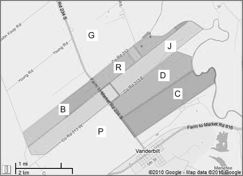
Now, consider the map shown here, where the (C) and (D) areas each represents 640 acres of Daniel’s 1,280 acres. The (D) area (different from the previous (D) areas) begins at what could be a straight ditch from the river to the base of a sand mound and then “southwestwardly” (S 45° W) out into the prairie. The (C) level is precise (and the same as before), since it was formally surveyed and eventually given to Christopher Haynes.
The Northeast End of Daniel's 1,280 Acres
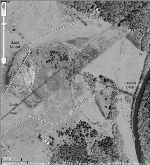
Although I visited this area a few times when I was a boy and the property was owned by Lorraine Fenner and her son Bill, I never paid any attention to things like a ditch leading from the river, and was never told that a sawmill had once been located here (Bill probably didn’t know that). I have not been back there in over 50 years. But what I know is that the steam-powered sawmill needed wood and water to produce the steam, and I imagine that the sawmill operator had dug a relatively-short but substantial ditch from the river up to the sawmill. During the past 160 years, the sides of the ditch have eroded and trees have grown up along it. It is difficult to identify a ditch in an aerial photograph because there is no depth perception, but zooming in on this area in Google Maps convinced me that this is the only thing along the river in this area that could have been a ditch. There’s also a bluff area containing what appears to be a sand mound in line with the ditch, and turning S 45° W at its “base” would take us out into the prairie along a line that is prominent even today. So I am pretty well convinced that this version of area (D) is correct. (There would have been very little incentive for subsequent owners of this land to fill in the ditch, which probably should have been called a canal.) To see this area in a "live" Google map, follow this link and zoom in if necessary for a closer view.
Why did Daniel’s 1,280 acres start at the ditch, rather than extend on to the river at the northeast end? More than likely, it was to save some of the bottomland and river frontage for the rest of the family. As it was, Daniel would be getting a large portion of the riverfront. Also, it was very common to divide land along major geographic features, such as the prominent ditch, that could be easily identified later. As it turned out, that odd-shaped piece of land that was not given to Daniel played a major role in future land dealings on the Haynes place.
An exciting benefit of finding a deed such as this, even though it was poorly written for my purposes, was to find that there was once a steam sawmill on the Haynes place! I had never even imagined that there was ever any type of sawmill there. And it was somewhat comforting to know that my great, great grandparents and their family and neighbors were able to build houses, barns and fences using “regular” lumber, rather than having to build them from logs. Of course, sawmills were common at that time, but to learn that one had been located on the Haynes place almost at the very beginning of its development partially answers the question of what living conditions were like back then. One book I had read, "A Journey Through Texas" by Frederick Law Omsted describes things in Texas in 1853, and repeatedly criticizes most Texas houses as being nothing more than rectangular log cabins with large gaps between the logs, no glass in the windows, dirt floors, etc., and with the people eating practically nothing but bacon and cornbread. But other writers of the time say that the people in Jackson County were wealthy before the Civil War (which began in 1861), and the ledgers of the owner (Menefee) of the general store in nearby Texana lists numerous items that were purchased there that could have been afforded only by persons of considerable means. And Celia Ann Haynes stated in a deposition to an 1891 lawsuit that "before the War, I had a large, fine home..." So there is ample evidence that the Haynes family had comfortable housing from the very beginning of the Haynes place.