Thomas Haynes Sells 1,000 Acres to James M. Stone (Area S1)
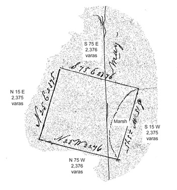
According to the census records of 1850, James M. Stone had been living on the Haynes place, working as a millwright. The first land that Thomas Haynes sold in the Musquiz Grant was an (almost) perfectly-square area of 1,000 acres near the center of the Musquiz Grant area, and was sold for $500 on September 3, 1850, as described in deed Book D, page 154. Once this land had been surveyed and staked, it became a sort of anchor point for Thomas to use in describing the surrounding areas in subsequent deeds. The plat shown here was included in the deed record book along with the deed, rather than be placed in a separate book of plats, and was very small (just about the size you see here). It also contained a couple of mistakes (probably made by the county clerk when the deed was copied into the deed record book), so I have repeated the notations on each of the four sides (correctly, I hope). The notation on the vertical axis is "Mag", for magnetic north.
Other than give the measurements of the property, the plat was not of much use to me in locating the area on a map, because it contained only one clue -- that the east side of the tract bordered on a marsh, but there is no shortage of marsh area in the Musquiz Grant. But I figured that it was probably good land that bordered a marsh, so that narrowed the set of possible locations. The square land area was rotated clockwise about 15 degrees from a true north/south orientation. This appears to have been done to align the east side with the bluff overlooking the lakes and Lavaca River flood plain “flats” below.
Other than give the measurements of the property, the plat was not of much use to me in locating the area on a map, because it contained only one clue -- that the east side of the tract bordered on a marsh, but there is no shortage of marsh area in the Musquiz Grant. But I figured that it was probably good land that bordered a marsh, so that narrowed the set of possible locations. The square land area was rotated clockwise about 15 degrees from a true north/south orientation. This appears to have been done to align the east side with the bluff overlooking the lakes and Lavaca River flood plain “flats” below.
Stone's 1,000 Acres (S1) with Other Tracts
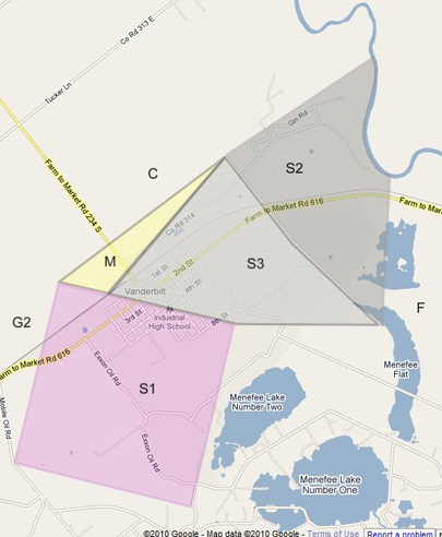
Amazingly enough, this area was (eventually) fairly easy to locate in the Google Maps aerial view, even though 160 years have passed! Land use along the southern and western boundary lines is so different from one side of the line to the other (farming versus ranching) that the boundary lines are very obvious, and having those two lines at right angles certainly helped. Once those two lines were drawn to the proper lengths on the map, adding the other two lines was a given. (Try zooming in on this area in the Google Maps satellite view and note the differences in land use along the southern and western boundary lines.)
Being able to locate this tract accurately on the map was a major milestone in constructing the overall map (and was a big morale booster, too) since the descriptions of several other tracts referred to the Stone survey.
In modern terms, this area is the southwestern half of the town of Vanderbilt, and includes all of the Industrial School District facilities in Vanderbilt, as well as most of the land between Vanderbilt and the Menefee lakes and “flats”. (Upon reviewing this, I checked again, and it turns out that this area includes the location of my childhood home on the NE corner of the intersection of Park Street and Third. We didn’t have any street signs back then, so we had no idea that our streets even had names. We had cousins (Ruth Haynes Hoffman family) across the street, and Uncle Basil and Uncle Ed lived only two blocks away.)