Trying to Resolve the Edward M. Glenn Dilemma
For a long time, I did not have the boundary (or boundaries) between the Thomas Haynes land and the Edward M. Glenn land on the southwest side of the map drawn correctly as shown in the map below and as specified in the deed in which Thomas bought the 1,900 acres from Glenn (Book 1, page 228). That deed says (material in parentheses added):
"In other words, the lower line to run out from the river must run South 45° West to the back line, and thence the course of the back line so far as to meet the course of the upper line, which (also) runs (South 45° West) from the bottom into the prairie and so as to include one thousand nine hundred acres."
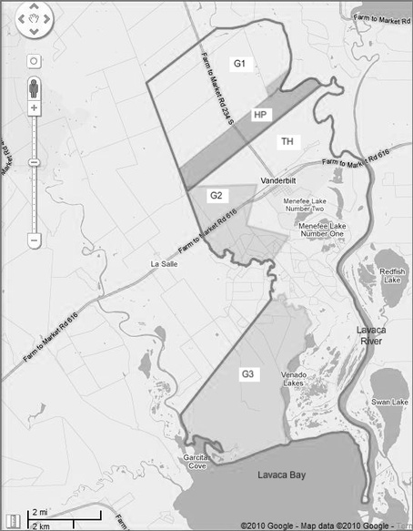
In other words (again), the lower line, and thus the division between Haynes and Glenn land, should be a single, straight line. Furthermore, the back line (southwestern side) should be a straight line. But I did not have a straight line for either one. Why? Well, it’s complicated. First of all, all of the early deeds we had ever found regarding the Haynes place and all of the land descriptions in those deeds (if you will allow me to make some reasonable assumptions to get around ambiguous deeds) never mentioned the fact that Haynes owned over 750 acres in a triangular area to the southwest (area P in some maps), just above Glenn’s middle 2,500 acres (G2).
Recall that Haynes briefly owned all of the lower part of the Musquiz grant. Then he had to give Glenn 3,000 acres out there on the west side (G2). To measure the 3,000 acres, they were supposed to follow these boundaries (paraphrased):
"Beginning on the east bank of said Venado (or Venadito) Creek …;
"Thence in a northeastern direction until it strikes the southeast corner of a survey made for James P. Stone, it being an elm standing on the brow of the bluff;
"Thence with the said Stone’s line westward to the southwest corner;
"Thence with said line northward a sufficient distance so that a line running westward to the rear line of the original survey,
"Thence with said original line to the corner on the Venado and down said creek to beginning point, may include an area of 3,000 acres..."
So they were supposed to draw a horizontal line (“so that a line running westward to the rear line of the original survey”) from Stone’s western line (of area S1) at whatever position was necessary to give 3,000 acres. Looking at the satellite view, I think that horizontal line is clearly visible about 90 percent of the way up the western side of Stone’s square area (S1). The only problem is, it is too far south, because if it were used, it would give only 2,500 acres or so for (G2). But if we take in the land (area P) between that line and the Haynes place lines I had been using, we get almost exactly 3,000 acres. Glenn may have been willing to accept only 2,500 acres here (G2), since he was getting about 5,000 acres farther down in the Musquiz grant in an area (G3) in which he was expecting only 3,000 acres, or he and Thomas may have settled on the more complicated boundaries I had been using. Of course, I did not know what they had decided about all this, so I assumed that Glenn had gotten the full 3,000 acres for (G2).
For a long time, I did not have the boundary (or boundaries) between the Thomas Haynes land and the Edward M. Glenn land on the southwest side of the map drawn correctly as shown in the map below and as specified in the deed in which Thomas bought the 1,900 acres from Glenn (Book 1, page 228). That deed says (material in parentheses added):
"In other words, the lower line to run out from the river must run South 45° West to the back line, and thence the course of the back line so far as to meet the course of the upper line, which (also) runs (South 45° West) from the bottom into the prairie and so as to include one thousand nine hundred acres."
In other words (again), the lower line, and thus the division between Haynes and Glenn land, should be a single, straight line. Furthermore, the back line (southwestern side) should be a straight line. But I did not have a straight line for either one. Why? Well, it’s complicated. First of all, all of the early deeds we had ever found regarding the Haynes place and all of the land descriptions in those deeds (if you will allow me to make some reasonable assumptions to get around ambiguous deeds) never mentioned the fact that Haynes owned over 750 acres in a triangular area to the southwest (area P in some maps), just above Glenn’s middle 2,500 acres (G2).
Recall that Haynes briefly owned all of the lower part of the Musquiz grant. Then he had to give Glenn 3,000 acres out there on the west side (G2). To measure the 3,000 acres, they were supposed to follow these boundaries (paraphrased):
"Beginning on the east bank of said Venado (or Venadito) Creek …;
"Thence in a northeastern direction until it strikes the southeast corner of a survey made for James P. Stone, it being an elm standing on the brow of the bluff;
"Thence with the said Stone’s line westward to the southwest corner;
"Thence with said line northward a sufficient distance so that a line running westward to the rear line of the original survey,
"Thence with said original line to the corner on the Venado and down said creek to beginning point, may include an area of 3,000 acres..."
So they were supposed to draw a horizontal line (“so that a line running westward to the rear line of the original survey”) from Stone’s western line (of area S1) at whatever position was necessary to give 3,000 acres. Looking at the satellite view, I think that horizontal line is clearly visible about 90 percent of the way up the western side of Stone’s square area (S1). The only problem is, it is too far south, because if it were used, it would give only 2,500 acres or so for (G2). But if we take in the land (area P) between that line and the Haynes place lines I had been using, we get almost exactly 3,000 acres. Glenn may have been willing to accept only 2,500 acres here (G2), since he was getting about 5,000 acres farther down in the Musquiz grant in an area (G3) in which he was expecting only 3,000 acres, or he and Thomas may have settled on the more complicated boundaries I had been using. Of course, I did not know what they had decided about all this, so I assumed that Glenn had gotten the full 3,000 acres for (G2).
The Edward M. Glenn Dilemma Solved
So this part of the map was still up in the air, and required another trip to Edna. I did not think we would find another deed from a Haynes to someone else involving that area, but hoped that one of the (probably many) Edward M. Glenn deeds would shed some light on this. Or perhaps a Whalen deed would help, since Mary Julia Haynes Whalen probably inherited the Haynes place land just above the Glenn land. The Glenn deeds did not help – he sold the 2,500 acre tract (G2) in one piece to the Sanford brothers, and their survey never mentioned what was to the north. But I finally found a Whalen deed from 1909 (or nearly 60 years later!) that included a survey of this area (which was then called “the Whalen pasture”) that proved that Thomas Haynes had owned the land. Either Mary Julia had inherited it or Celia Haynes had given it to Michael Whalen, and Whalen sold 550 acres there (lower part of area P) to W. W. McCrory, who subdivided it into 6 small farm tracts.