The Haynes Place Land in 2010
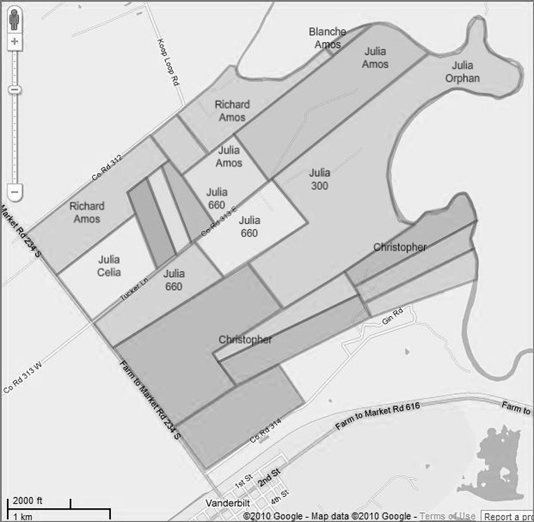
Please fast forward to the present. This map shows the original Haynes place land east of the highway (FM 234) as it exists today, in terms of individual pieces of property. This map was drawn by transferring property lines from a map given to me by the Jackson County Appraisal District onto a Google Map. (I faked some of the lines down in the lower part of the map because they were not shown on the Appraisal District map). I then added some labels in order to show how the areas in this map relate to the 20 areas used in most of the other maps. There is not a natural one-to-one correspondence, of course, because properties have been bought and sold, split, combined, etc. over a period of 100 years. But some of the original Haynes place lines are still recognizable. Regardless, I have tried to label some of the current properties to indicate which Thomas Haynes grandchild inherited or bought them. However, I have used a different labeling scheme this time. For example, instead of using “(R)” to mark the area eventually inherited by Richard Daniel Haynes, this time I used “Richard/Amos” to indicate that Richard inherited the land from Amos W. (who inherited it from Thomas and Celia). In other cases, where the path to ownership was more complicated, I have used some other scheme; for example, the area labeled “Julia/300” suggests the complicated history of the 300 acres for which Mary Julia Haynes Whalen inherited 150 acres but purchased the rest. (In other words, this map will not mean much to you unless you have viewed and understood the remainder of this web site.)
In terms of current ownership, all I can report is that the 125 acre tract labeled “Richard/Amos” on the river is still owned by descendants of Thomas and Celia Haynes; namely, the children and grandchildren of Ruth Haynes Hoffman, daughter of Richard Daniel and Mabel Haynes.
Follow this link to a more colorful Google Maps version of this map, but without the labels.
(I may try to describe what happened between 1910 and 2010 in a later version of this web site.)