Thomas Haynes Buys 1,900 Acres from Edward M. Glenn
As part of their partitioning of the Musquiz Grant land, Haynes and Glenn apparently got together to work out the details. When the dust had settled, it turned out that Haynes needed to buy 1,900 acres of land from Glenn in order to have the Haynes place where he wanted it. So on November 4, 1850, or about a year since he began living there and developing it, Thomas Haynes bought the upper 1,900 acres of the Haynes place from Glenn, as recorded in Book 1, page 228. The price was a relatively expensive $1 per acre, but one interpretation of Glenn’s two deeds suggests that he had paid at least that much for the land.
The deed was very poorly written (again, inexcusable for two land professionals). Haynes and Glenn knew what they had agreed to, but the deed didn’t say it. Here’s the land description from the deed (items in parentheses added):
Beginning five thousand seven hundred (5,700) varas (5,278 yards) on a straight line from the upper corner of said original survey (Musquiz Grant survey) on the river;
Thence into the said river on a line parallel with the said upper line, to corner, below said Haynes’ present residence;
Thence up said river with its meanders to mouth of a deep ravine or gully some hundred varas above the enclosure and some 700 or 800 varas (750 yards) above his dwelling house;
Thence with right angles with the river through bottom timber a sufficient distance so that a line at right angles shall include with the present improvement one hundred acres of what was and is timber and bottom land;
And continuing this course out into the prairie an indefinite distance, but so far that a line at right angles, on the same course of the back line of the original survey, and one running from thence North 45° East will strike the beginning corner on the river.
In other words, the lower line to run out from the river must run South 45° West to the back line, and thence the course of the back line so far as to meet the course of the upper line, which (also) runs (South 45° West) from the bottom into the prairie and so as to include one thousand nine hundred acres.
It’s a good thing they added that clarification in the last sentence, because the previous part of the land description does not say the same thing!
So where is this 1,900 acre tract on the maps? Although this may not be the best place to look, in the "big map" of the entire Haynes place and Musquiz Grant, it is roughly all of the top two “rows” of land (areas B, R, 5, and J), which constitute 1,400 acres of it, plus 400 acres more at the top of the next row (areas P, D, 3, and O), plus the 100 acre boot-shaped area (T) on the upper right. But those are all later subdivisions of the Haynes place, and had not even been contemplated at the time. What we need is a map that shows the 1,900 acres exactly.
In the map shown below, this area is clearly shown (since that’s the purpose of the map). It is the darker area (HP) across the upper portion of the map; Glenn had owned down to the bottom of this area. Glenn still owned the upper 5,000 or so acres (G1) that remained from his original 7,000 acres, as well as 2,500 acres on the left in the middle (G2) and 5,000 acres on the left at the bottom (G3). Thomas Haynes already owned everything (area TH) below the 1,900 acres he bought, except for Glenn’s land in (G2) and (G3) and the 1,000 acres he had sold to James J. Stone.
The Musquiz Grant Land After the Haynes/Glenn Agreement
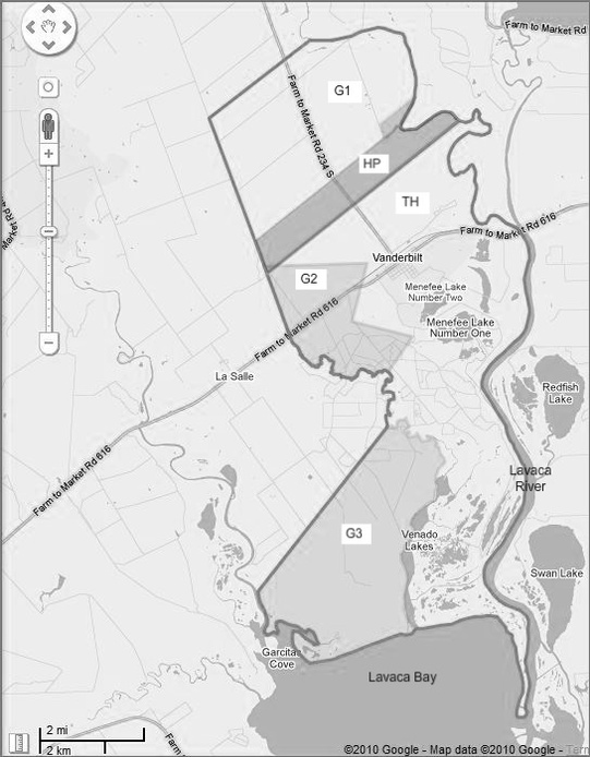
Notice the slight overlap between (HP) and (G2). Haynes should own that land, since he had given Glenn area (G2) as part of the division of the Musquiz Grant land, and then bought the 1,900 acres in area (HP) from Glenn. I have seen maps drawn both ways. In fact, the first map I found for this area gave the overlap land to Glenn, but my version gives the land to Haynes. (It’s not all that important, of course, since we’re talking about only a few acres out of many thousand. But thinking that the two areas should overlap, and then finding proof that they really did, was very reassuring that I was on the right track in figuring things out.)