Blanche C. Haynes Owens and Richard Daniel Haynes Divide Their Land
The 1900 U. S. Census for Jackson County shows a household consisting of four people: Julia E. Haynes (mother of Blanche and Richard); Blanche Owens; William Owens (husband of Blanche); and Richard D. Haynes, who was listed as a farmer. More than likely, they were living at the traditional Haynes place home site. Richard D. married Mabel Meredith about that time, and that marriage would have led to the need for additional housing, as well as a desire to “go our own way.”
All we need now is for Richard Daniel Haynes to grow old enough (age 25, as his father’s will dictated) to own his share of the land outright. In the interim (since 1994), his older sister, Blanche C., had been in charge of all the land. The big day finally arrived, but much later than expected, because Richard D. was about 30 when the deeds were finally signed in 1906. The partitioning was recorded in Book 6, page 326, and dated October 17, 1906, although Blanche did not sign until December 22, 1906.
The two siblings had 775 acres to split between them, so in a 50-50 split, each would have received 387½ acres. But Blanche received 407½ acres and Richard received 367½ acres, so Blanche wound up with 20 acres of Richard’s share. This split probably wasn’t inequitable, because Richard got the river end of the property, as well as the traditional Haynes place home. Blanche’s share was mostly way out in the prairie, over 1½ miles from the river, with no bottom land at all. She probably wanted some bottom land and river frontage for firewood and recreation. As a result, she received five acres of land on the river, at the very easternmost tip of Richard’s land.
Blanche Haynes Owens and Richard Daniel Haynes Divide Their Land
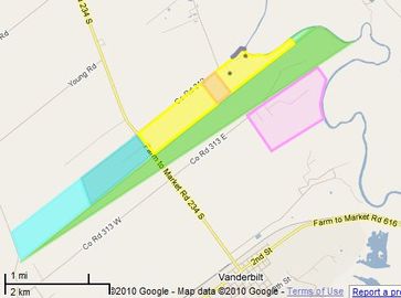
Blanche's land is blue, Richard's is yellow
On the map, Richard and Mabel Haynes received the land shown in yellow, with about 1,000 yards of river frontage; and Blanche and William Owens received the land to the southwest (shown in blue), plus the five acres of river-front land at the tip of Richard’s land (shown in green). Their sister, Mary Julia Haynes Whalen, owned the larger green and pink areas.
Looking at the map, we would be tempted to say that Richard’s share of the land extended all the way to highway FM 234, and that Blanche had the land to the southwest of the highway. In today’s terminology, that is exactly true; however, the road did not exist then. When land was donated for the road two years later, the road was positioned so that it passed exactly along the boundary line between Richard’s and Blanche’s properties. So the boundary line determined the road position, rather than visa versa.
Looking at the map, we would be tempted to say that Richard’s share of the land extended all the way to highway FM 234, and that Blanche had the land to the southwest of the highway. In today’s terminology, that is exactly true; however, the road did not exist then. When land was donated for the road two years later, the road was positioned so that it passed exactly along the boundary line between Richard’s and Blanche’s properties. So the boundary line determined the road position, rather than visa versa.