Celia A. Haynes Clarifies Gift of 640 Acres to the Christopher Haynes Heirs
The death of Amos Haynes seems to have set off a wave of land transactions involving the Haynes place. The heirs of Christopher Haynes (his wife, Annie; and his three children, Robert S., Mollie A., and Amos C.) apparently were all living in Bee County, farther down in South Texas. All but Robert S. wanted to sell their land (area C), and they had an interested buyer in George Menefee, who was putting together a large ranch. However, the long-lingering surveying error that had misplaced the stake on the lower corner of the 300 acre tract (3) immediately above the 640 acre tract that they had inherited from Christopher naturally affected the size of their property, which was now less than 640 acres.
Rather than just let them live with the problem and have less acreage, Celia solved the problem by having a new survey done and giving them enough additional land to bring the total acreage back up to 640. The original deed from Celia to Christopher for the 640 acres had read as follows:
"The lower, undivided half of a tract of land sold and conveyed by Daniel Haynes to said Celia A. Haynes on the 6th day of July A.D. 1860, containing twelve hundred and eighty (1,280) acres, and which is more particularly described by metes and bounds as follows:
"Beginning on the river Lavaca, at the mouth of a ditch near the place where Platt’s Steam Saw Mill formerly stood;
"Thence with said ditch (a straight line) to its termination near the base of a sand mound;
"Thence southwardly (should be "southwestwardly") to a small mott on the bluff;
"Thence pursuing the same course that a line at right angles will intersect M. Stanton’s upper line, and with that line to the river;
'Thence up the river to the place of beginning, will include the area of said twelve hundred and eighty across of land, …"
As stated previously, because that description does not contain any measurements (or metes), it is impossible to say exactly where the land is, although I think I have it figured out pretty well. In contrast, the new deed, as recorded in Book Q, page 361 on July 7, 1892, described the tract in more precise surveying terminology (distances in parentheses added):
"Beginning at the NE corner of a survey of 612 acres (S2) sold by (James Stanton to) Wm. M. Sanford to George Menefee on the west bank of the Lavaca River;
"Thence S 50° W (no variation) with the NW boundary line of said survey, at 1,040 varas a large post oak tree marked (X over three hacks, or horizontal bars), at 2,140 varas (1,981 yards) a stake and corner of fence (and the NW corner of said survey);
"Thence S 44¼° W with said Menefee’s fence and line (M) 1,910 varas (1,769 yards) to a stake in same;
"Thence N 40° W 1,091½ varas (1,011 yards) to a stake in prairie;
"Thence N 50° E 3,596 varas (3,330 yards) to a stake on said Lavaca River, from which a live oak 16 inches in diameter marked X bears S 37¾° W 130 varas;
"Thence down the meanders of said river to the place of beginning, containing six hundred and forty (640) acres."
The old deed described the property boundaries by starting at the top of the property and coming down toward Stanton’s property (S2), (since sold to Sanford and then to Menefee), whereas the new deed started at a known (and unmovable) point, which was the NE corner of Menefee’s property and worked its way up.
Old and New Surveys for Christopher's 640 Acres
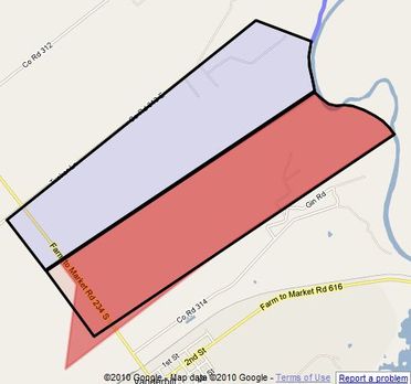
Exactly what changed with respect to the boundaries is difficult to tell, insofar as the written description of the boundaries is concerned, except for the lower boundary line. But "a picture is worth a thousand words" as the map on the left illustrates. The black borders show the original 1,280 acres that Celia bought back from Daniel, and the lower half of that was given to Christopher. The reddish-orange area represents the correct new survey (but not the area described in Celia's new deed!) It turns out that the area described in Celia's new deed that was to clarify the situation was itself in error! The original deed has the lower boundary being a straight line, whereas the new deed has it following the original line for 2,140 varas and then turning a little more toward the south (5¾°) for 1,910 varas. That's fine. That turn is visible here. This slight turn was introduced about sixteen years earlier when Celia traded the 138 acre tract (M) below this to Menefee, so this re-surveying soaked up a very slim triangular “orphan” that would have existed without it. But the new deed does not include the larger triangular area of about 43 acres added to the SW end of Christopher's tract. In fact, that triangular area was not mentioned even in any subsequent deed, although it did appear in the surveyor's plat! Somehow, it just kept on being overlooked, even though it is required in order to provide the full 640 acres. Luckily, all that was required here was to move the southwestern boundary farther out into the pasture (P) to make room for the additional 43 acres. (It's a good thing that there's an almost inexhaustible supply of land out there to the southwest!)
But why that particular triangular area? After all, it only extends about two-thirds of the way up the SW end of Christopher's tract. Why not use a triangle that extends all the way to the top of Christopher's land? Well, we're getting a little ahead of ourselves at this point, but since I've revealed the addition of the triangle, I may as well explain it: As mentioned above, Amos C. and Mollie A. wanted to sell their two-thirds of the land to Menefee, but Robert S. did not. The added triangle matched up with Menefee's existing property and the land to be sold by Amos and Mollie; Robert kept the upper one-third that did not include the added triangle.
But why that particular triangular area? After all, it only extends about two-thirds of the way up the SW end of Christopher's tract. Why not use a triangle that extends all the way to the top of Christopher's land? Well, we're getting a little ahead of ourselves at this point, but since I've revealed the addition of the triangle, I may as well explain it: As mentioned above, Amos C. and Mollie A. wanted to sell their two-thirds of the land to Menefee, but Robert S. did not. The added triangle matched up with Menefee's existing property and the land to be sold by Amos and Mollie; Robert kept the upper one-third that did not include the added triangle.
The New Survey of Christopher's Land, as Drawn
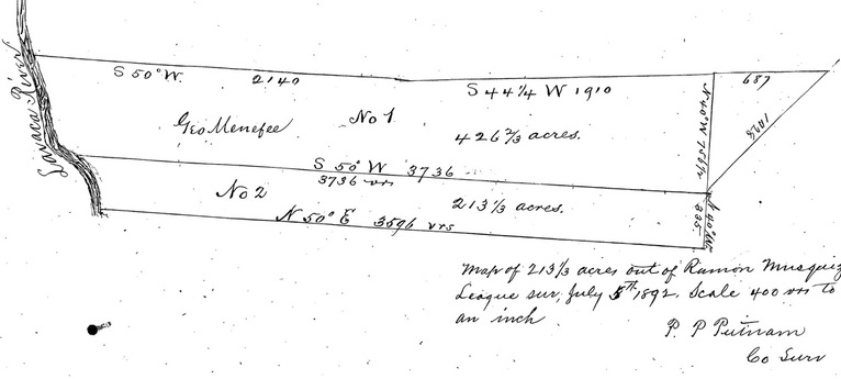
This is the copy of the survey that was eventually attached to the deed from Mollie A. to Menefee (but not to the deed from Celia that cleared up the surveying error). In this view, as drawn, it is readable, but is upside-down; that is, the top is south (actually SE) and the bottom is north (actually NW). See below for the same survey with the proper orientation (but with upside-down wording.)
The New Survey of Christopher's Land, With the Correct Orientation
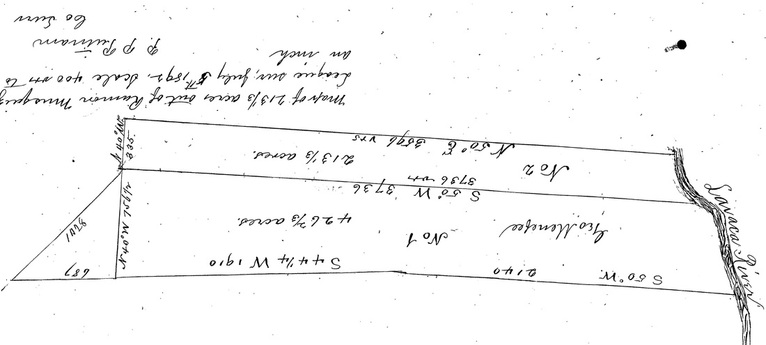
This is the same survey, but inverted so north (actually NW) is up and the Lavaca River is on the northeast. The shape of Christopher's land should be more recognizable here, even though the wording is upside-down, since it matches the orange area shown in the first map above. Amos C. and Mollie A. got the lower two-thirds and Robert S. got the upper third. What was originally Stanton's 612 acres (area S2) is immediately below this on the river; what eventually became Menefee's area (M) is below this on the left; and the upper half of area (D) that Celia had bought back from Daniel is immediately above this. Notice that the course of the Lavaca River along this property is very different than it is now, and I based my course of the river in this area upon this survey.
The triangular area added on the left (or southwest) was required in order to make the total area of the bottom two-thirds be 426⅔ acres. As nearly as I can tell, its dimensions are 687 x 1428 x 756.5 varas, which would give the triangle an area of approximately 46 acres (if it were a right triangle, although it isn't. In a later Menefee deed, an area of 42¾ acres was used; not that knowing the exact acreage is all that important.) Well, actually, it is kind of important, because this triangle of 42¾ acres turned out to be the very last piece of land in the entire Musquiz Grant that I had not accounted for!
The triangular area added on the left (or southwest) was required in order to make the total area of the bottom two-thirds be 426⅔ acres. As nearly as I can tell, its dimensions are 687 x 1428 x 756.5 varas, which would give the triangle an area of approximately 46 acres (if it were a right triangle, although it isn't. In a later Menefee deed, an area of 42¾ acres was used; not that knowing the exact acreage is all that important.) Well, actually, it is kind of important, because this triangle of 42¾ acres turned out to be the very last piece of land in the entire Musquiz Grant that I had not accounted for!