Celia Haynes Trades 138 Acres to George Menefee, Jr. for a Share of Fences
We take them for granted today, but during the first twenty-five years or so of the Haynes place, there were very few fences other than “plank” fences or perhaps the split rail variety, so the cattle roamed far and wide. We found several deeds that included cattle, and the usual terminology was something like “… all that certain stock of cattle ranging in Jackson and surrounding counties, estimated at about four hundred head, branded “CH” and marked crop and underbit in the right ear.” The cattle of different owners intermingled and could only be identified by their brands and ear marks.
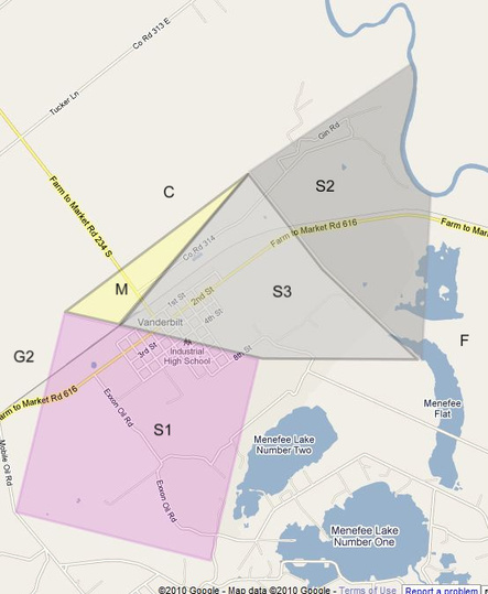
The invention of barbed wire (or “bob wire” before we knew better) in 1867, then its improvement in 1874, eventually led to the use of barbed wire fences in Jackson County. George Menefee, Jr. must have been one of the early adopters. He had purchased the 612 and 500 acre tracts (S2 and S3) directly below the Haynes place that had once belonged to James M. Stanton, and also owned James J. Stone's (S1) and the Schneider heirs' (F) as well.
On September 28, 1876, Celia and Amos Haynes traded 138 acres of land (M) in a long, triangular strip to George Menefee, Jr. for half ownership of all of his fences between his land and Haynes place land. The trade is recorded in Book H, page 392. The land being traded is shown on the map above as a yellow triangle directly above Stone’s perfectly-square area (S1) near the center of the map, and below Christopher Haynes's area (C) area in the Haynes place. The fences would then have been on the upper boundaries of areas (S2) and (M), which form the lower boundary of Christopher's area (C).
It is interesting that Celia and Amos were trading land for fences along Haynes place land that then belonged exclusively to Christopher. To me, this suggests that even though Christopher legally owned his land, the entire Haynes place was still being considered by the family to be an entity in itself.