Book D Page 154 Thomas Haynes Sells 1,000 Acres to James J. Stone
September 23, 1850
State of Texas Link to Google Map
County of Jackson
This indenture made and entered into this 23rd day of September 1850, between Thomas Haynes of the one part and James Stone of the other part
Witnesseth that the said Haynes in consideration of five hundred dollars ($500) in hand paid, the receipt whereof is hereby acknowledged, that this day and doth by these presents sell, bargain, and convey unto the said Stone
One thousand (1,000) acres of land being a part of a five and one-half league tract granted to Ramon Musquiz, situated and being in the County of Jackson, State of Texas, on the Lavaca River and Bay, and the part hereby sold and conveyed is bounded as follows:
Beginning at an elm tree six inches in diameter and marked # standing on the bluff, a little below the wooded draw that runs into the bayou which enters the river near Dimitt’s point, this marked tree is the southern of three standing midway up the bank
Thence North 75° West 2,276 varas (2,107 yards) to corner in open prairie:
Thence North 15° East 2,375 varas (2,199 yards) to corner;
Thence South 75° East 2,376 varas (2,199 yards) to the corner at the edge of the marsh from which a live oak tree 11 inches in diameter marked X bears N 75 W 40 varas;
Thence across the marsh South 15° West 2,375 varas (2,199 yards) to corner;
Thence North 75° West 100 varas (93 yards) to the beginning.
To have and to hold the said one thousand acres of land to the said Stone, his heirs and assigns forever and the said Haynes for himself, his heirs &c doth covenant and agree to warrant and defend the title of the said one thousand acres to the said Stone, his heirs &c against himself, his heirs and all others forever by these presents. Witness his hand and scroll for seal the day and year aforesaid.
Thomas Haynes (seal)
State of Texas
County of Jackson
I, George R. Billups of the county court do hereby certify that Thomas Haynes personally appeared before me and acknowledged that he signed the within and for the uses and purposes there set forth. Given under my hand and seal of office this 4th January 1851 G. R. Billups Clk
Recorded 8 May 1851
Survey for James Stone of one thousand acres of Land from the lands of Thomas Haynes Esq. Beginning at the Elm tree (6 in. diameter marked X) the southern of three about midway up the bluff; thence North 75 West 2276 varas to corner in open prairie; Thence North 15 East 2375 varas to corner; Thence South 75 East 2376 varas to corner at the edge of the Marsh from which a Live Oak Tree 18 inches in diameter marked X bears N 15 W 40 varas; Thence across the Marsh South 15 West 2375 varas to corner; Thence N 75 W 100 varas to the beginning point.
Thos. Simon, County Surveyor, Jackson County, March 20, 1850
Plat of Stone's 1,000 Acres
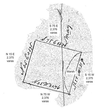
This is a perfectly square area. The plat was included with the deed, but some bearings were copied incorrectly. The correct bearings are shown in the typewritten text. The bluff referred to overlooks the Lavaca River floodplain and Menefee flags south of the present town of Vanderbilt. Follow the Google Map link given above for the present view of this land.