The Amos Haynes Estate Partitioning Begins in 1894
Since the death of Amos W. Haynes in 1891, Mary Julia Haynes Whalen and her husband, Michael C., had been taking care of the estate, and an outside administrator apparently had been appointed to look out for the interests of Blanche C. and Richard D. Haynes, all pending the coming-of-age of Blanche. Amos had given all of his cattle to his wife Jennie, so unless the Whalens had brought in more cattle, the land had laid fallow for several years.
In 1894, when Blanche was about 22 and her younger brother Richard Daniel, was about 18, the Whalens, as executrix and executor, presented a proposal for the partitioning of the Amos W. Haynes land. It described two tracts: 1,400 acres and an undivided one-half interest in 300 acres. The boundaries were described more precisely than in the past, indicating that the land had finally been surveyed.
The Land in the Amos Haynes Estate
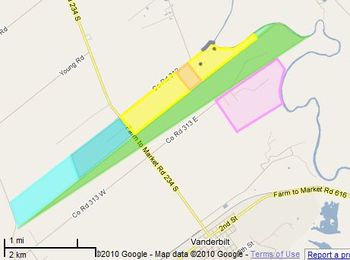
This map shows the land in Amos’s estate. Basically, the Whalens proposed that Blanche and Richard jointly would receive the upper 775 acres (in the blue and yellow row) of the 1,400 acre tract, and that Mary Julia would receive the remainder (625 acres, in the green triangle) and the 150 acres of the one-half interest in the 300 acre pink tract. This division was approved by the court. This division certainly made sense, since the Whalens already owned the other one-half interest in the 300 acres, and the 625 acres would be immediately above it. They also owned all of the land to the southwest, so the fact that Mary Julia would be inheriting an unwieldy, long triangular property was no problem. Blanche and Richard would get a single piece of land, including the traditional home site where Blanche probably was already living with her husband William and her mother Julia E. Blossman Haynes. Richard Daniel apparently had been living in Corpus Christi with his maternal grandmother Blossman. Blanche and Richard could decide later how to divide their 775 acres.
Two Versions of the "Same" 300 Acres
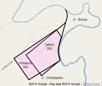
The version of the 300 acre tract that had been used in multiple Haynes family land transactions in the past (Celia's 300 acres) did not match the pink one shown here as proposed by the Whalens. It had been surveyed incorrectly, had the wrong orientation, and overlapped Christopher's 640 acres. To get around this problem, Michael Whalen, executor of Amos’s estate and Celia’s “go-to guy”, proposed this new version of the 300 acre tract (Whalen' 300 acres), as shown here in pink, which did resolve the surveying problems. But another problem had arisen over the years in that the river had changed course, creating a “bonus” area between the new 300 acre tract and the river. Using Google Maps, the bonus area appears to have an area of about 175 acres today. We do not know whether all of this new land was added as the result of one major flood or several. (For example, the nearby coastal town of Indianola had been wiped out twice by hurricanes in 1875 and 1876, and those storms could have been the cause of the floods that changed the course of the Lavaca.
Although the new 300 acre tract then fit in properly with those around it, the existence of the bonus area also created a fundamental problem (to me, anyway) – what should be done with the bonus area; that is, who owned it?
• Celia had definitely intended to give it to Thomas S. as part of his 300 acres, and Thomas S. had sold it to Amos and the Whalens. If Mary Julia inherited the half belonging to Amos, the Whalens would own both half interests. Since they would then own all the land around the bonus area, it would be inaccessible to anyone but them, so it would be logical for the Whalens to claim the bonus area. Besides, Celia had stated in the sale of her final piece of property to Michael Whalen that it was her intent to be selling all of her remaining land. But did she own the orphan area at that point; that is, was it hers to give away, since she had previously given it to Thomas S.?
• Some argument could be made that if the 300 acre tract was going to be redefined, it could have been shifted to the east to include the tip on the east, thus moving the southwestern boundary line toward the river, and creating a different bonus area between the new 300 acre tract and the land that Celia had owned but had since sold to the Whalens, again in a deed stating that “it is my intent to sell all of my remaining land.” This makes a stronger case that Celia would have owned that bonus area, and thus the extra land would have belonged to the Whalens.
• Celia’s version of the 300 acre tract could have been used as it was, because Christopher’s heirs had been given a little more land on the southwest end of their property to make up for their loss on the river end. After all, this version of the 300 acres had already passed through three successive transactions (Celia to Thomas S.; Thomas S. to Amos and the Whalens; and Amos to his heirs). It seems kind of questionable to redefine its boundaries at this point.
• Since the Whalens knew about the problem when they partitioned Amos’s land and essentially created the bonus area, they could have stated that Amos had owned, say, 1,400 + 150 + 175 = 1,725 acres, instead of 1,550. This would have made the land allocated to Blanche and Richard Daniel larger by about 88 acres. We know nothing of the discussions that occurred regarding this discrepancy, or whether there were any, but the Whalens version of the boundaries were used and the Whalens wound up with the bonus area. (By this time, all of Celia’s sons were dead and she probably was in poor health, or even dead, and only Michael and Mary Julia Whalen could be depended upon for advice and to get things done, since the other Amos heirs, Blanche C. and Richard D., were only 22 and 18, respectively, and Richard wasn’t even around to pay attention to what was going on. Their mother, Julia Elena Haynes, was still around and may have been living with Blanche, but probably was not a big buddy of either Celia or the Whalens, so they probably would not have paid much attention to her.)
• It would certainly be appropriate here to argue that this interpretation of things is all wrong; that the bonus area did not exist in the 1890’s; that in a big flood that occurred later, the river may have carved itself a new path and increased the amount of land on the Haynes side of the river. But the facts point to the previous interpretation: most of the course change had occurred sometime before, because Michael Whalen acknowledged the existence of the bonus area in his description of the property in 1894; he actually created it in his proposal for the partitioning of the land. The property description states that the lower boundary line of the 625 acre (green) tract was 9,350 varas (8,657 yards, or about 5 miles) long, which makes that line extend across most of the bonus area and eliminate only small parts of the two loops in the river when measured with Google Maps. Zooming in on the satellite view of this part of the Lavaca River clearly shows numerous previous paths that the river has taken, but offers no indication of when those changes occurred, of course.
You may be wondering “Why are you imagining all these problems, Herb?” The answer is that there was a problem, and it appears to have been resolved by the Whalens and in their favor. But in their defense, they already owned most of the other land, and arranging their land this way or that way to provide a mechanism to give Blanche and Richard their fair share of the land certainly makes sense. Perhaps as a “Haynes” it is natural for me to think that the “Whalens” may have taken advantage of the youthfulness and inattention of Blanche and Richard, even though Mary Julia was just as much a “Haynes” as her half-siblings. But why did Michael appear to be so magnanimous in his proposal to the probate court to say that if Amos’s 1,400 acre tract (a solid chunk of land) could not be divided so as to give Blanch and Richard just 775 acres of it, he would let them take in some of his land next door? Was he trying to snow the court, or what? ‘Sure wish I knew!
At this stage in the history of the Haynes place, Blanche C. and Richard D. jointly owned the upper 775 acres (inherited blue and yellow areas); Mary Julia Haynes Whalen owned the next 625 acres (inherited green area), the 660 acres out in the prairie (purchased) that Celia had owned, and about 475 acres (purchased and inherited pink and bonus areas) below her 625 acres. Robert S. Haynes owned the upper 213⅓ acres (inherited) of the 640 acres his family had owned, and George Menefee owned the lower 426⅔ acres. The Whalens also owned the 750 or so acres in the southwestern pasture area, as well as any other orphan areas that Celia had owned.
In terms of housing, as they had been in 1880 and would still be doing in 1900, Blanche probably was living together with her husband, Will Owens, and her mother, Julia E., on the Haynes place. Because of the missing 1890 census, anything else is just a guess. Richard had been living in Corpus Christi with his grandmother, Elena Blossman, so he may have gone back there because it was going to be a long wait (seven years) until he would be in charge of his own land. Celia may have been living in the house that the Whalens owned on the lower part of their land, and Robert S. may have taken over the former home of his parents on his land.