Thomas Haynes Sells 6,000 Acres to Daniel R. Coleman (Area C1)
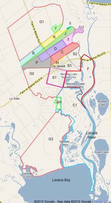
Thomas Haynes sold a large chunk (area C1 on the lower right of this map) of the remaining land he owned in the Musquiz Grant to Daniel R. Coleman on February 21, 1851. The deed (Book D, page 133) says that the area should be between 6,000 and 8,000 acres; however, Google Maps suggests that the area is slightly less than 6,000 acres. So this tract perhaps was 1,000 to 2,000 acres or so too small, whereas the tract to the west that was given to Edward M. Glenn (G3) was 2,000 or so acres too large. Someone just didn’t seem to know quite enough about how Venadito Creek divided the lower half of the Musquiz Grant land! But for $800, or only $0.133 per acre, Coleman still got a very good deal, especially if he or his heirs could hang around until oil and natural gas were discovered in the Menefee flats and on the West and Ward ranches many years later.
This large area is bounded by Venado Creek and Venado Lakes on the west, and the Lavaca River on the east. It extends from near Vanderbilt all the way south to Lavaca Bay, and has many miles of creek, lake, bay, and river frontage. The northwestern portion contains higher land that was home of the original Magnolia (now ExxonMobil) oil “camp” (employee housing areas, since removed) as well as major oil and gas producing and processing facilities. Much of the remaining area is part of the Lavaca River flood plain, but portions are still useful for ranching. The home of Mrs. A. P. Ward, a prominent Jackson County citizen, was located on the river within this area, near the mouth of Menefee Bayou at the Lavaca River. Viewing this area using the Google Maps “Map” option as shown here shows the presence of the large areas of marsh. (Two of my uncles, Ed Haynes and Lewis Hoffman, used to tow their boats from Vanderbilt all the way to a boat ramp on the Lavaca near Mrs. Ward’s home, and then go on down the river to fish or troll for shrimp in Redfish Bay.)
This large area is bounded by Venado Creek and Venado Lakes on the west, and the Lavaca River on the east. It extends from near Vanderbilt all the way south to Lavaca Bay, and has many miles of creek, lake, bay, and river frontage. The northwestern portion contains higher land that was home of the original Magnolia (now ExxonMobil) oil “camp” (employee housing areas, since removed) as well as major oil and gas producing and processing facilities. Much of the remaining area is part of the Lavaca River flood plain, but portions are still useful for ranching. The home of Mrs. A. P. Ward, a prominent Jackson County citizen, was located on the river within this area, near the mouth of Menefee Bayou at the Lavaca River. Viewing this area using the Google Maps “Map” option as shown here shows the presence of the large areas of marsh. (Two of my uncles, Ed Haynes and Lewis Hoffman, used to tow their boats from Vanderbilt all the way to a boat ramp on the Lavaca near Mrs. Ward’s home, and then go on down the river to fish or troll for shrimp in Redfish Bay.)
The deed mentions that the 200 acres that Haynes had previously sold to Thomas G. Bankhead (see preceding deed and area (BH)) were within this large area and were not being included in this sale. And curiously, although most deeds included a statement that the seller would defend the buyer’s title to the land from all lawful claims (no expensive title insurance was required then!), this deed included a specific exclusion to that guarantee, namely, that Haynes would not defend against a claim by the heirs of Philip Dimitt for one labor (177 acres) of land. Dimitt had been granted a league of land on the other (east) side of the Lavaca River, so why he or his heirs would claim ownership of any land on the west side of the river is not known, unless they had become “squatters” in much the same way that Bankhead had, and were expecting to be able to buy the land, but Thomas wouldn’t sell. Haynes had apparently had a run-in with the Dimitts over their claim and didn’t want anything else to do with them. As nearly as we can tell from the reading we have done, Dimitt had a trading post on the east side of the river, and may have wanted land on the west side of the river to stock supplies and serve customers on that side of the river.