Thomas Haynes Sells 120 Acres to Elizabeth A. Lytle (Area T near Top of Map)
The Haynes Place in 1857
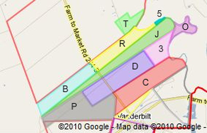
This is a small area, but it caused much consternation in the conduct of this research, probably because its existence conflicts with what I believed while growing up. There is a ravine or gully where a creek or branch flows into the Lavaca River up there at the “top” of the Haynes place. That gully shows up even in the original Musquiz Grant survey made by the Mexican surveyor Carbajal in 1829, and is prominently mentioned in the deed for the original purchase of the 1,900 acres of upper Haynes place land from Edward M. Glenn in 1850. The land to the north of the gully is a wide swatch of bottomland that extends up the river for about 3 miles, whereas the Haynes place land immediately to the south is mostly higher land, except right along that creek. (Click here to see a Google map containing area T.)
As mentioned previously, when Thomas Haynes purchased the Haynes place land from Edward M. Glenn, the deed described the land in this area vaguely as follows:
"… Thence up said river with its meanders to mouth of a deep ravine or gully some hundred varas (about 90 yards) above the enclosure and some 700 or 800 varas (about 750 yards) above his dwelling house;
"Thence with right angles with the river through bottom timber a sufficient distance so that a line at right angles shall include with the present improvement one hundred acres of what was and is timber and bottom land;
"And continuing this course out into the prairie an indefinite distance,…"
That was in 1850. The Haynes family had been living there since 1849, and had apparently felled some of the timber, according to the deed. (Imagine those logs being dragged over a mile by horse or mule teams to be cut into lumber at Platt’s steam saw mill.) Seven years later, on March 19, 1857, Thomas Haynes sold 120 acres of this land across the gully to Elizabeth Ann Lytle, as recorded in Book E, page 428, for $1,000 (which is by far the greatest price per acre ($8.33) that Thomas received for any Musquiz Grant land he sold).
The property description in the deed reads as follows:
"… containing about one hundred and twenty (120) acres, more or less, and bounded as follows, to wit:
"Beginning at the mouth of the gully or bayou, just above the house of said Haynes, and extending up the same to an ash tree, near an old bridge;
"Thence across the hill in a direction to a bunch of post oaks standing in the prairie to a stake standing thirty yards beyond the line of the plank fence extending from said Lytle’s plantation to said Haynes’;
"Thence with the course of said fence and parallel with it, the same distance of thirty yards from it, to the dividing line between said Haynes and Lytle;
"Thence along said line to the beginning."
Particularly perplexing in this case is that the property bounds are so vague that it is impossible to tell which land Thomas was selling. In addition, he was supposed to have only 100 acres of “timber and bottom land” (also poorly described) in this area, yet somehow he wound up selling 120 acres to Elizabeth, while still retaining any timber and bottom land on his side of the creek.
In trying to draw this area on the map, I didn’t have much to go on, other than the fact that it was 120 acres across the gully above the Haynes home. I also knew that Thomas later sold Elizabeth another 50 acres. So I looked and looked at a close-up of the area in the Google satellite view, and tried various configurations that yielded 170 acres, but nothing seemed satisfactory. There were some possibilities that looked promising on the basis of land use, with clear boundary lines, but none that resembled the deed description and also had the correct area. Finally, I just gave up and drew in a sort of rectangular area, but later modified it to the boot-shaped area shown as area (T), which does include about 170 acres.
I was hoping that by examining some later deed in which Elizabeth Lytle sold or willed her property away, that I would find a better description of this small piece of land. But as nearly as I can tell, Elizabeth, who later married Stockdale (whatever happened to Thomas Bankhead?), owned about 3,000 acres here. Two or three generations later, their land was divided among three heirs, and was formally surveyed, but this small piece of land was simply a part of a much larger tract, and its boundaries were not mentioned at all, although its inclusion in the larger tract was specifically mentioned.
When I was a boy, the river end of the gully had plenty of water in it, but the gully was usually dry a short distance upstream. The land across the gully was owned by Elmer Spree, and I think some of it is still owned by his descendants.
Thomas Haynes Sells 50 Acres to Elizabeth A. (Lytle) Stockdale (Area T near Top of Map)
This is out of order chronologically, but since we have reported that Thomas Haynes sold 120 acres to Elizabeth A. Lytle, we may as well take care of the other 50 acres he sold her in the same general area (T). Five years later, on April 12, 1862, that land was sold, as recorded in Book G, page 54, for only $2 per acre. The property description reads as follows:
"Beginning at a stake thirty yards from the plank fence enclosing said Elizabeth’s field in the upper line of the said Haynes as per deed from Edward M. Glenn to him and the same stake mentioned in a deed from said Haynes to Elizabeth A. Lytle of 19th March 1857;
"Thence along said line to a point opposite or in the course of the lower line of said Stockdale’s pasture fence;
"Thence with said fence towards the river to the lower corner of the tract contained in the same deed of the 19th March 1857;
"Thence along another line of said tract to the beginning."
Since I was unable to determine where the original 120 acres were located, I obviously had no luck in figuring out where this 50-acre addition was located. It’s all included in the one 170 acre area (T) shown on the map.
Here’s a challenge for you:
Try to determine where the 120 acre tract and this 50 acre tract are located. The property descriptions are given above, and the deed from Glenn to Haynes is also given. With Google Maps, zoom in to this area and try to come up with an area that meets the descriptions and has an area of about 170 acres. If you’re like me, you will be unable to even visualize the shapes of these two areas. Try to draw a sketch of everything, including Elizabeth’s plank fence, the stake, Elizabeth’s field, etc. If you come up with something you’re proud of, let me know, please.