Book Q, Page 593 Robert S. Haynes Gives Up His Interest in 426⅔ Acres to George Menefee
December 10, 1892
Note: Christopher Haynes had three children: Robert S., Amos C., and Mollie A. His wife was Annie C. His mother, Celia A., gave him 640 acres in 1875 (see book H, page 223). After he died, Annie gave the land to her three children, but the original survey was in error. So after a new, formal survey, Celia re-gifted the 640 acres to them with proper metes and bounds (see Book Q, page 361). The land was sold in three separate transactions. Amos C. (and Annie) sold his one-third to George Menefee on July 12, 1892 (see Book Q, page 364) for $666.66. Mollie A. (and Annie) sold her one-third to George Menefee on December 10, 1892 (see Book Q, page 591). This deed immediately follows the preceding deed from Robert S. Haynes’ sister and mother. Robert S. gives up his interest in the 426⅔ acres of family land, but retains 213⅓ acres. The original deed includes a plat, which was introduced previously but is still available here.
State of Texas
County of Bee
Know all men by these presents: That I, Robert S. Haynes of the County of Bee and State aforesaid, for and in consideration of the sum of one dollar ($1), to me in hand paid by George Menefee, and for the further purpose and consideration of making a division and partition of that certain tract of 640 acres of land, a part of the Ramon Musquiz leagues, now owned by me the said Robert S. Haynes and the said George Menefee, have granted, sold, and conveyed, and by these presents do grant, sell, and convey unto the said George Menefee of the County of Jackson and State of Texas, all that certain tract of land lying and being in the said County of Jackson and described as follows:
A part of the Ramon Musquiz leagues:
Beginning at the NE corner of a survey of 612 acres of land sold by Wm. M. Sanford to George Menefee on the west bank of the Lavaca River;
Thence S 50° W (no variation) with the NW boundary line of said survey, at 1,040 varas a large post oak tree marked (X over three hacks, or horizontal bars), at 2,140 varas (1,981 yards) a stake and corner of fence (and NW corner of said survey);
Thence S 44¼° W with said Menefee fence and line at 1,910 varas (1,769 yards) to a stake in same;
Thence N 40° W 756½ varas (700 yards) to a stake in prairie;
Thence N 50° E 3,736 (3,459 yards) varas to a live oak 15 inches in diameter marked (X over three hacks, or horizontal bars) on the west bank of said Lavaca River;
Thence down the meanders of said river to the place of beginning, containing 426⅔ acres.
The said Menefee having purchased the undivided interest of Mrs. Annie Haynes, Amos C. Haynes, and Mollie A. Haynes, which they as heirs at law of C. Haynes, deceased, owned in the above mentioned tract of 640 acres.
A plat of said tract of 640 acres is hereto attached for record, showing the division of said land between myself and said George Menefee. The said Menefee getting tract no. one and I tract no. two as designated on said plat.
To have and to hold the above described premises, together with all and singular the rights and appurtenances thereto in anywise belonging unto the said George Menefee, his heirs and assigns forever, and I do hereby bind myself, my heirs, executors, and administrators to warrant and forever defend, all and singular, the said premises unto the said George Menefee, his heirs and assigns against every person whomsoever lawfully claiming or to claim the same, or any part thereof through me.
R. S. Haynes
The State of Texas
County of Bee
Before me R. C. Eeds, Clerk of the County Court in and for Bee County Texas on this day personally appeared R. S. Haynes known to me to be the person whose name is subscribed to the foregoing instrument and acknowledged to me that he executed the same for the purposes and consideration therein expressed.
Given under my hand and seal of office this 10th day of December AD 1892
R. C. Eeds, Clerk C. C. Bee Co Texas
Filed for record Jany 3d 1893 at 11 o'clock A.M.
Recorded January 26th 1893 at 5 o'clock P.M.
(Inverted) Plat Included with Deed
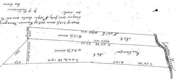
This is a scanned copy of the plat that accompanied the deed. Unfortunately, the writing on the plat was upside-down, since the river is supposed to be on the right (east) as shown here, so this is an inverted copy of the plat. Robert S. had the upper 1/3 as shown here.
Plat Included with Deed
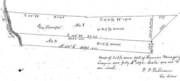
This is the same plat, but presented so that the writing is right-side-up.