Thomas Haynes Sells 200 Acres to Thomas G. Bankhead (Area BH)
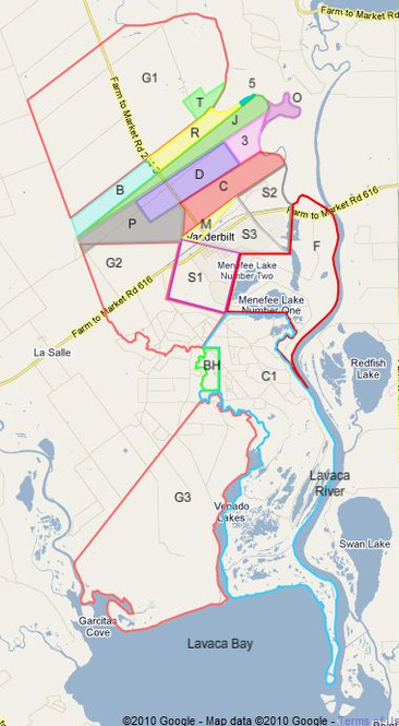
On July 15, 1851, Thomas Haynes sold a 200 acre tract (area BH in the lower center of this map) to Thomas J. Bankhead for $100. This was another case (besides that of Thomas Haynes himself) in which the buyer lived on the land and made improvements before purchasing it. This deed is listed out of order relative to the immediately following deed to Daniel P. Coleman because Haynes had already agreed to sell this land to Bankhead before Coleman bought the surrounding land (C1). Bankhead had at least built a fence, and presumably a house, by the time he bought the land.
Unfortunately, the deed description of the land (Book D, page 178) was so poorly written that I was never able to determine the specific location of this 200 acre tract. Here’s the description:
"Beginning at two large live oaks marked “T.G.B.” and standing near the corner of said Bankhead’s fence and near the bank of Venado creek; thence down said creek (east side) to the mouth of the first ravine; thence east five hundred (500) yards; thence at right angles for quantity."
It’s easy enough to determine the general location of this land, since Venado (or Venadito) Creek is the major creek that flows down the center of the lower portion of the Musquiz Grant land and separates Glenn’s area (G3) from Haynes’s area (C1). We know that Bankhead’s land (BH) is on the east side of the creek (within area C1), and probably is located closer to the top of that area than the bottom (it’s too marshy down there). Unfortunately, I don’t know where Bankhead’s fence was or which ravine they were talking about. Even the last phrase: “thence at right angles for quantity” is puzzling. Apparently, we’re supposed to start on the creek, go down the creek to the ravine (side 1), then go right (East) 500 yards (side 2), and thence at right angles for quantity (sides 3 and 4). So “at right angles for quantity” must mean that after we go East 500 yards, we turn and go North far enough so that if we then turn West and go back toward the starting point, we’ll have an area of 200 acres. That’s easy enough to do, if only I knew where those two large live oaks were. But I don’t, so I just guessed about where to insert this area on the map.
In modern terms, this land is probably good grazing land, but its more important use is for oil and gas wells and associated processing equipment on the West or Ward ranches. Unfortunately for him, but Thomas Bankhead did not hold on to the land long enough to benefit from that, and sold it for $400 in 1859 (Book E, page 687) to William Coleman, who probably was related to Daniel P. Coleman, who owned the surrounding 6,000 acres (area C1). However, he may have gained a better prize, because it looks like he may have married Elizabeth Ann Lytle, who owned 3,000 acres above the Haynes place that she bought from Edward M. Glenn.